Websterville, Vermont facts for kids
Quick facts for kids
Websterville, Vermont
|
|
|---|---|

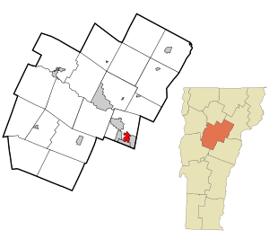
Location in Washington County and the state of Vermont
|
|
| Country | United States |
| State | Vermont |
| County | Washington |
| Area | |
| • Total | 1.7 sq mi (4.4 km2) |
| • Land | 1.7 sq mi (4.3 km2) |
| • Water | 0.04 sq mi (0.1 km2) |
| Elevation | 1,310 ft (400 m) |
| Population
(2010)
|
|
| • Total | 550 |
| • Density | 324/sq mi (125.0/km2) |
| Time zone | UTC-5 (Eastern (EST)) |
| • Summer (DST) | UTC-4 (EDT) |
| ZIP code |
05678
|
| Area code(s) | 802 |
| FIPS code | 50-77800 |
Websterville is a small community in Vermont, United States. It is known as a census-designated place (CDP). This means it's an area that the government counts as a separate place for population studies.
Websterville is located in the town of Barre. It is part of Washington County. In 2010, about 550 people lived there.
Before 2010, Websterville was part of a larger CDP. That area was called Graniteville-East Barre. It included three small villages: Graniteville, East Barre, and Websterville.
Where is Websterville Located?
Websterville is in the northeastern part of the United States. It is in the state of Vermont. The community is found within Washington County.
How Big is Websterville?
The United States Census Bureau collects information about places. They say Websterville covers about 4.4 square kilometers. Most of this area is land. About 4.3 square kilometers is land. A small part, about 0.1 square kilometers, is water. This means about 2.68% of Websterville is water.
See also
 In Spanish: Websterville para niños
 | Valerie Thomas |
 | Frederick McKinley Jones |
 | George Edward Alcorn Jr. |
 | Thomas Mensah |

