Graniteville, Vermont facts for kids
Quick facts for kids
Graniteville, Vermont
|
|
|---|---|

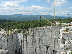
Rock of Ages quarry in Graniteville
|
|

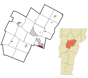
Location in Washington County and the state of Vermont
|
|
| Country | United States |
| State | Vermont |
| County | Washington |
| Area | |
| • Total | 1.7 sq mi (4.5 km2) |
| • Land | 1.7 sq mi (4.4 km2) |
| • Water | 0.04 sq mi (0.1 km2) |
| Elevation | 1,264 ft (385 m) |
| Population
(2010)
|
|
| • Total | 784 |
| • Density | 451/sq mi (174.2/km2) |
| Time zone | UTC-5 (Eastern (EST)) |
| • Summer (DST) | UTC-4 (EDT) |
| ZIP code |
05654
|
| Area code(s) | 802 |
| FIPS code | 50-29425 |
Graniteville is a small community located in the town of Barre, in Washington County, Vermont, United States. It's known as a census-designated place (CDP), which means it's a specific area identified by the U.S. Census Bureau for statistical purposes, but it's not an officially incorporated town or city.
In 2010, about 784 people lived in Graniteville. Before 2010, Graniteville was part of a larger CDP that included two other villages: East Barre and Websterville.
Graniteville is famous for its granite industry. It is home to the Rock of Ages granite company. You can also find the E. L. Smith Quarry here, which is known as the world's largest deep hole granite quarry.
Exploring Graniteville's Location
Graniteville is situated in the beautiful state of Vermont. It's part of Washington County.
How Big is Graniteville?
According to the United States Census Bureau, Graniteville covers a total area of about 4.5 square kilometers (about 1.7 square miles). Most of this area, about 4.4 square kilometers (1.7 square miles), is land. A small part, about 0.1 square kilometers (0.04 square miles), is water.
See also
 In Spanish: Graniteville (Vermont) para niños
 | Frances Mary Albrier |
 | Whitney Young |
 | Muhammad Ali |

