Wedgewood Brook facts for kids
Wedgewood Brook is a small stream located in Woodbridge, Middlesex County, New Jersey, United States. It flows into the Woodbridge River.
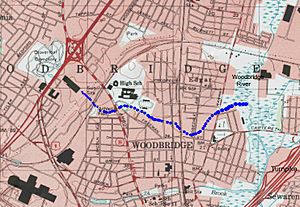
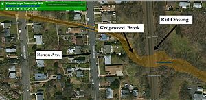
The brook starts near Woodbridge High School. It then flows east, passing under streets like Wedgewood Avenue, Amboy Avenue, and Barron Avenue. Finally, it joins the Woodbridge River in Woodbridge River Park. People have become very interested in this brook because it has flooded many times in recent years.
Contents
Why Does Wedgewood Brook Flood?
The Woodbridge River, which Wedgewood Brook flows into, empties into a larger waterway called the Arthur Kill. This area often experiences flooding from the tides, which is called tidal flooding.
But Wedgewood Brook also has another type of flooding called fluvial flooding. This happens when a lot of rain makes the brook overflow its banks. The land around the brook doesn't absorb much water because it's covered by buildings and roads. This makes flooding worse, especially where the land slopes steeply.
How Buildings Affect Flooding
One big problem is a narrow tunnel, called a culvert, where the brook goes under a railroad track. This tunnel is quite small, which causes water to back up and flood the areas upstream. Experts believe that a very large flood, sometimes called a "100-year flood," could put the area under nine feet of water.
Over time, more homes were built on land that used to be marshes and meadows. These natural areas used to soak up extra water like a sponge. Now, with more buildings, there's less natural space to absorb the water, making floods happen more often.
Hurricane Sandy's Impact
In 2012, Hurricane Sandy caused a lot of damage in the area around Wedgewood Brook. It brought both tidal flooding from the ocean and fluvial flooding from heavy rain. People described the water as a "tsunami-like water wall" because it was so powerful and destroyed homes nearby.
After Hurricane Sandy, the town of Woodbridge started a special program. Using money from the New Jersey Buyout Program, they offered to buy homes in areas that flood often. Many homeowners accepted, and their houses were torn down.
Planning for the Future
Woodbridge's actions are sometimes called a "slow motion evacuation" from climate change. As people move out of these flood-prone areas, the town plans to turn the land back into a "floodplain forest." This means planting native trees, shrubs, and grass. These plants will help the land absorb more water and create a natural buffer between the river and homes.
However, not everyone in Woodbridge wants to sell their homes. Some people think that the idea of their properties being underwater by the year 2050 feels too far away to worry about now. This can make it harder to create large natural areas that protect the town from future floods.
 | Valerie Thomas |
 | Frederick McKinley Jones |
 | George Edward Alcorn Jr. |
 | Thomas Mensah |


