
Woodbridge River facts for kids
Quick facts for kids Woodbridge River |
|
|---|---|

Tidal branch of Woodbridge River in Woodbridge marsh
|
|
| Other name(s) | Woodbridge Creek |
| Country | United States |
| State | New Jersey |
| City | Woodbridge Township |
| Physical characteristics | |
| Main source | Northeast Woodbridge Township |
| River mouth | Arthur Kill |
| Length | 5 mi (8.0 km) |
The Woodbridge River, also known as Woodbridge Creek, is a river located in Woodbridge Township, New Jersey, in the United States. This river is an important waterway, but it often floods because of strong storms and changing weather patterns. Scientists expect more flooding in the future due to rising sea levels.
The Woodbridge River area has special places set aside to protect its many different plants and animals. The local government is also buying some properties near the river. This is part of a plan called "managed retreat," which helps create natural areas that can absorb floodwaters and protect other homes.
Contents
River's Path and Features

The Woodbridge River flows south for about 5 miles (8 km) through Woodbridge Township. It eventually empties into the Arthur Kill, which is a busy waterway.
The river starts in the far northeast part of the township, near Omar Avenue. For about three-quarters of its length, the Woodbridge River is a tidal river. This means its water levels rise and fall with the ocean's tides. The water in the lower part of the river is brackish, which is a mix of fresh and salty water.
The river acts as a drainage basin for about half of Woodbridge. This means it collects rainwater and runoff from a large area. Important smaller streams that flow into the Woodbridge River include Heards Brook and Wedgewood Brook.
Understanding Flooding

There's a long history of flooding along the Woodbridge River and its smaller streams. This flooding often happens because of high tides and heavy rainfall.
How Flooding Happens
The most serious flooding happened during Superstorm Sandy in 2012. The water level in the Woodbridge River reached 12 feet (3.7 meters) high during that storm. Many low-lying areas along the river are only 6 to 7 feet (1.8 to 2.1 meters) above sea level, making them very vulnerable.
The streams and rivers in Woodbridge are known for having "flashy" floods. This means water levels can rise very quickly. Flooding happens not only from high tides but also from heavy rain. The ground in the area is often covered by buildings and roads, which means less water can soak into the soil. This makes flooding worse, especially when combined with steep slopes.
Long coastal storms, like nor'easters, can cause both tidal and rain-related flooding at the same time. This can make the Woodbridge River and its streams stay flooded for days before the water goes down. Flooding has become more frequent over time in these areas.
Homes and Flood Zones
Years ago, people built homes in areas that used to be salt marshes, wetlands, and meadows. These natural areas are important because they can absorb extra water. When these areas were developed, the land lost some of its ability to soak up floodwaters.
A map from 1770 shows that all the land around the river was salt marsh. In one area called Watson-Cramptom, which was hit hard by Hurricane Sandy, the land next to the Woodbridge River was planned for many homes. This included areas that were wetlands and meadows. When Sandy arrived, it was like a "tsunami-like water wall" that destroyed many homes nearby.
Adapting to Flooding
After Superstorm Sandy, Woodbridge Township started a program to buy and remove homes in areas that flood often. This program uses money from the New Jersey Buyout Program. Woodbridge's actions are sometimes called a "slow motion evacuation from climate change."
As people move out of these flood-prone areas, the land is being turned into a "floodplain forest." This means planting native trees, shrubs, and grass. These natural areas can help protect other homes by absorbing floodwaters. Not everyone wants to sell their homes, but the goal is to create large natural buffers between the river and neighborhoods.
Protecting Nature and Wildlife
The Woodbridge River area is home to important natural spaces that help protect wildlife and the environment.
Ernest L. Oros Wildlife Preserve
In 2013, the Ernest L. Oros Wildlife Preserve was opened. This preserve covers 99 acres (40 hectares) along the Woodbridge River. It has helped restore the river and the land next to it, turning it into a nature preserve.
Many different bird species have been seen along the river, especially at the Oros Preserve. These include wading birds like great blue herons and great egrets, as well as bald eagles, belted kingfishers, and Canada geese. Eight types of mammals have been noted, such as raccoons and red foxes. Nine kinds of fish have also been found, including the American eel. The Preserve is considered a special "hot spot" for nature in an otherwise very developed area.
Woodbridge River Park
Downstream from the Oros Preserve, near Port Reading Avenue, is Woodbridge River Park. This park is 40 acres (16 hectares) large. It has many channels, backwaters, and oxbows (curved sections of the river) that are great for canoeing.
Images for kids
-
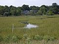
Tidal branch of Woodbridge River in Woodbridge marsh
-
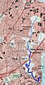
Woodbridge River course in Woodbridge, New Jersey
-
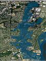
Woodbridge, New Jersey, area inundated by Woodbridge River after Hurricane Sandy (Source: USGS Sandy Storm Tide Mapper)
