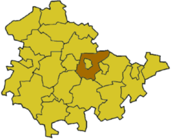
Weimarer Land Rural District facts for kids
Quick facts for kids
Kreis Weimarer Land
|
|
|---|---|
 |
|
| Country | |
| State | Thuringia |
| Capital | Apolda |
| Area | |
| • Total | 803 km2 (310 sq mi) |
| Population
(2002)
|
|
| • Total | 90,262 |
| • Density | 112.41/km2 (291.13/sq mi) |
| Time zone | UTC+1 (CET) |
| • Summer (DST) | UTC+2 (CEST) |
| Vehicle registration | AP |
| Website | http://www.weimarer-land.de |
Weimarer Land is a Landkreis, which means a rural district or county, located in the eastern part of Thuringia, Germany. The city of Weimar is completely surrounded by this district, but it is not part of the district itself.
Contents
History of Weimarer Land
The history of Weimarer Land goes back to a larger district called Großkreis Weimar. This district was created in 1922. This happened after the German state of Thuringia was officially formed. At that time, the cities of Weimar and Apolda were not included in this larger district.
In 1952, the district was divided into two separate parts: one around Weimar and one around Apolda. Later, in 1994, these two parts were joined together again. However, the new district did not cover exactly the same area as the original one before 1952.
What Does the Coat of Arms Mean?
The coat of arms for Weimarer Land tells a story about the area's past. It shows symbols from the historic states that once existed in this region.
- The lion on the right side represents the dukes of Saxe-Weimar-Eisenach. They were important rulers in this area long ago.
- The wheel in the top left corner is known as the Wheel of Mainz. This symbol shows the historical connection to the Archbishopric of Mainz.
- The three apples are a special symbol for the town of Apolda. These apples were used in the coat of arms of the governors who once ruled Apolda.
This coat of arms was officially approved on November 24, 1994.
Towns and Villages in Weimarer Land
Weimarer Land is home to several towns and many smaller villages. Some towns manage their own affairs, while others are part of groups called Verwaltungsgemeinschaften. These are like administrative communities where smaller towns and villages work together.
Towns and Municipalities Not in a Verwaltungsgemeinschaft
These are towns and municipalities that manage their own local government:
- Apolda
- Bad Berka
- Bad Sulza
- Blankenhain
- Auerstedt
- Eberstedt
- Flurstedt
- Gebstedt
- Großheringen
- Ködderitzsch
- Niedertrebra
- Obertrebra
- Rannstedt
- Reisdorf
- Saaleplatte
- Schmiedehausen
- Wickerstedt
Administrative Communities (Verwaltungsgemeinschaften)
These are groups of towns and villages that share administrative tasks:
| Verwaltungsgemeinschaften | ||
|---|---|---|
|
|
|
| 1seat of the Verwaltungsgemeinschaft; 2town | ||
See also
 In Spanish: Distrito de Weimarer Land para niños
 | Shirley Ann Jackson |
 | Garett Morgan |
 | J. Ernest Wilkins Jr. |
 | Elijah McCoy |

