Wellington Land District, Tasmania facts for kids
Quick facts for kids WellingtonTasmania |
|||||||||||||||
|---|---|---|---|---|---|---|---|---|---|---|---|---|---|---|---|

Location in Tasmania
|
|||||||||||||||
|
|||||||||||||||
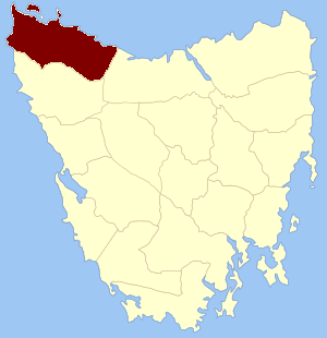
Wellington Land District is a special area of land in Tasmania, Australia. It's one of twenty such areas that help organize how land is owned and used. Think of it like a big, official map section!
Contents
What is Wellington Land District?
Wellington Land District is one of the twenty "land districts" in Tasmania. These districts are part of a system called Cadastral divisions of Tasmania. This system helps the government keep track of all the land. It shows who owns what and where properties are located.
Where is Wellington Land District Located?
Wellington Land District is found in the northwest part of Tasmania. It has some interesting neighbors! To its north, northwest, and northeast, it borders the Bass Strait. This is the sea that separates Tasmania from mainland Australia.
To the east and southeast, it shares a border with the Devon Land District. To the south and southwest, it's next to the Russell Land District. And to the west, it meets the vast Southern Ocean.
Why are Land Districts Important?
Land districts like Wellington are very important for many reasons. They help people buy and sell land easily. They also make sure that land records are clear and accurate. This system helps with planning new towns and roads. It also makes sure that everyone knows where their property lines are.
A Bit of History
Long ago, Wellington Land District was known by a different name. It used to be one of the 18 "counties" of Tasmania. Over time, the system changed to the land districts we have today. This change helped to make land management even better and more organized.
 | Delilah Pierce |
 | Gordon Parks |
 | Augusta Savage |
 | Charles Ethan Porter |

