Wellow Brook facts for kids
Quick facts for kids Wellow Brook |
|
|---|---|

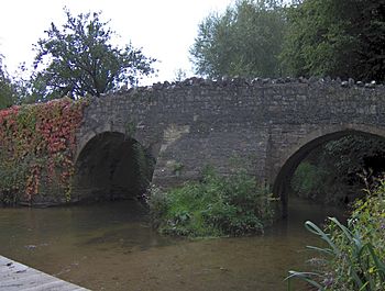
Medieval packhorse bridge at Wellow, Somerset
|
|
| Country | England |
| County | Somerset |
| Cities | Radstock, Wellow |
| Physical characteristics | |
| Main source | Kilmersdon, Somerset, England 51°15′34″N 2°26′00″W / 51.25944°N 2.43333°W |
| River mouth | Midford Brook Midford, Bath and North East Somerset, Somerset, England 51°20′27″N 2°20′32″W / 51.34083°N 2.34222°W |
| Basin features | |
| Tributaries |
|
The Wellow Brook is a small river located in Somerset, England. It flows through a beautiful valley and has played a part in the history of the area. This brook is about 17.8 km (11.1 mi) long from Radstock to the River Avon.
Contents
Journey of the Wellow Brook
The Wellow Brook begins its journey near Ston Easton Park in the village of Ston Easton. From there, it flows towards the east, passing through Midsomer Norton.
Where the Brook Flows
As it continues its path, the Wellow Brook reaches an area west of Radstock. Here, it is joined by another river called the River Somer. It also gets water from a stream that starts in Kilmersdon. This stream is formed by two smaller brooks, Snails Brook and Kilmersdon Brook.
After these rivers join, the Wellow Brook flows through the village of Wellow. Eventually, it meets the Cam Brook at a place called Midford. When these two brooks combine, they form a new stream known as the Midford Brook. This new brook then flows into the River Avon near the Dundas Aqueduct.
Valley and Landscape
The valley where the Wellow Brook flows has rounded, rolling hills. These shapes were created over a long time by erosion, which is when natural forces like water wear away the land.
Water Features and Trees
You can find several springs along the sides of the valley. These springs feed streams that often have many trees growing along their banks. The valley floors are narrow but flat, and the brook winds freely across its flood plain. A flood plain is a flat area next to a river that can get flooded when the river overflows.
Deep Sections and Historical Use
In some places, the Wellow Brook is quite deep and has steep sides. This natural feature was used during World War II for defence. Many concrete pillboxes, which are small bunkers, were built along the brook. These were part of the GHQ Line, a defence system to protect Britain from a possible invasion.
Local Wildlife and Nature
The area around the Wellow Brook is important for local wildlife. Groups like the Cam Valley Wildlife Group are interested in protecting the nature here. They study the plants and animals that live in the valley.
Historical Connections
The Wellow Brook has a connection to the history of the area. Along its banks, you can still see parts of the Somerset Coal Canal. This canal was built in the 19th century to transport coal from the Somerset Coalfield.
 | George Robert Carruthers |
 | Patricia Bath |
 | Jan Ernst Matzeliger |
 | Alexander Miles |

