Wesley Hills, New York facts for kids
Quick facts for kids
Wesley Hills, New York
|
|
|---|---|

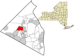
Location in Rockland County and the state of New York.
|
|
| Country | United States |
| State | New York |
| County | Rockland |
| Incorporated | December 7, 1982 |
| Area | |
| • Total | 3.38 sq mi (8.74 km2) |
| • Land | 3.35 sq mi (8.68 km2) |
| • Water | 0.02 sq mi (0.06 km2) |
| Elevation | 538 ft (164 m) |
| Population
(2020)
|
|
| • Total | 6,116 |
| • Density | 1,824.58/sq mi (704.44/km2) |
| Time zone | UTC-5 (Eastern (EST)) |
| • Summer (DST) | UTC-4 (EDT) |
| ZIP codes |
10901, 10952, 10977
|
| Area code(s) | 845 |
| FIPS code | 36-79174 |
| GNIS feature ID | 0979941 |
| Website | http://www.wesleyhills.org/ |
Wesley Hills is a small community called a village in New York, United States. It's part of the town of Ramapo in Rockland County. The village is located near other places like Viola, Harriman State Park, Pomona, and New Hempstead. In 2010, about 5,628 people lived there.
Wesley Hills was formed in 1982. People who moved there wanted to keep the area's peaceful, garden-like feel.
The current mayor is Marshall Katz. He became mayor in 2014 after the previous mayor, David Goldsmith, stepped down. Mayor Katz ran for election in 2015 and was chosen by the community.
Contents
Exploring Wesley Hills' Location
Wesley Hills is located at a specific point on the map: 41.155795 degrees North and -74.075257 degrees West. This is like its address on the Earth.
How Big is Wesley Hills?
The village covers an area of about 3.4 square miles (8.7 square kilometers). Most of this area is land, with a very small part being water.
Who Lives in Wesley Hills?
Every ten years, the United States counts its population in a census. This helps us understand how many people live in different places.
Population Growth Over Time
Here's how the number of people living in Wesley Hills has changed:
- 1990: 4,305 people
- 2000: 4,848 people
- 2010: 5,628 people
- 2020: 6,116 people
A Look at the Community in 2000
In 2000, there were 4,848 people living in Wesley Hills. They lived in 1,430 homes, and 1,272 of these were families.
- Most people (88.3%) were white.
- About 4.95% were African American.
- About 4.52% were Asian.
- A small number were Native American or Pacific Islander.
- About 3.71% of the population identified as Hispanic or Latino.
Many homes (45.2%) had children under 18 living there. Most families (81.4%) were married couples. The average household had about 3.37 people.
Age Groups in the Village
The population of Wesley Hills in 2000 included:
- 33.7% were under 18 years old.
- 5.9% were between 18 and 24 years old.
- 24.4% were between 25 and 44 years old.
- 27.0% were between 45 and 64 years old.
- 9.1% were 65 years or older.
The average age in the village was 36 years old.
Understanding Income Levels
In 2000, the average income for a household in Wesley Hills was $91,613. For families, it was $98,102. The average income per person was $32,785. A small number of families (3.7%) and individuals (7.1%) lived below the poverty line.
Learning in Wesley Hills
Most students in Wesley Hills attend schools in the East Ramapo Central School District. Some students in the western part of the village go to schools in the Suffern Central School District.
Places to Visit
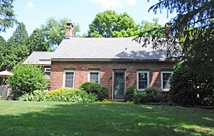
- Gurnee-Sherwood House - This is a historic house listed on the National Register of Historic Places (NRHP).
See also
 In Spanish: Wesley Hills para niños
 | Isaac Myers |
 | D. Hamilton Jackson |
 | A. Philip Randolph |


