West Bend, Iowa facts for kids
Quick facts for kids
West Bend, Iowa
|
|
|---|---|
 |
|
| Motto(s):
"A Rock Solid Community"
|
|

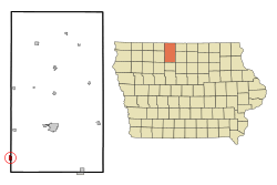
Location of West Bend, Iowa
|
|
| Country | |
| State | |
| Counties | Palo Alto, Kossuth |
| Area | |
| • Total | 0.88 sq mi (2.27 km2) |
| • Land | 0.88 sq mi (2.27 km2) |
| • Water | 0.00 sq mi (0.00 km2) |
| Elevation | 1,191 ft (363 m) |
| Population
(2020)
|
|
| • Total | 791 |
| • Density | 901.94/sq mi (348.22/km2) |
| Time zone | UTC-6 (Central (CST)) |
| • Summer (DST) | UTC-5 (CDT) |
| ZIP code |
50597
|
| Area code(s) | 515 |
| FIPS code | 19-83550 |
| GNIS feature ID | 0465615 |
| Website | City of West Bend, Iowa |
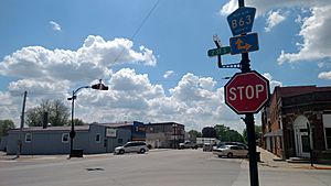
West Bend is a small town located in the state of Iowa in the United States. It is unique because it sits across two different areas called Palo Alto County and Kossuth County. In 2020, about 791 people lived there.
Contents
History of West Bend
West Bend started in the early 1880s. This happened after a railroad, the Burlington, Cedar Rapids and Northern Railway, was built through the area.
How West Bend Got Its Name
The town was first called Ives. It was named after the president of the railroad company. But the people living there wanted a different name. They chose West Bend because of a bend in a nearby river. West Bend was actually the very first town in Palo Alto County.
Railroad Station Development
The town promised the railroad a small tax of five cents. This tax would help build a train station if the railroad made a stop there. The railroad agreed, and the station was built.
Geography of West Bend
West Bend is located in the northwest part of Iowa. It is split between the southwest part of Kossuth County and the southeast part of Palo Alto County. Even though it's in two counties now, it first began in Palo Alto County.
Land Area
The United States Census Bureau says that West Bend covers about 0.89 square miles (2.27 square kilometers) of land. There is no water area within the town limits.
Railroad Lines
West Bend is served by an old railroad track. This track used to belong to the Rock Island Railroad. Now, the Union Pacific Railroad owns it, but it is not used very often.
Population Information
| Historical populations | ||
|---|---|---|
| Year | Pop. | ±% |
| 1890 | 325 | — |
| 1900 | 538 | +65.5% |
| 1910 | 679 | +26.2% |
| 1920 | 969 | +42.7% |
| 1930 | 634 | −34.6% |
| 1940 | 737 | +16.2% |
| 1950 | 772 | +4.7% |
| 1960 | 910 | +17.9% |
| 1970 | 865 | −4.9% |
| 1980 | 941 | +8.8% |
| 1990 | 862 | −8.4% |
| 2000 | 834 | −3.2% |
| 2010 | 785 | −5.9% |
| 2020 | 791 | +0.8% |
| Source: and Iowa Data Center Source: |
||
2020 Population Details
In 2020, West Bend had 791 people living in 351 households. About 226 of these were families. The town had about 902 people per square mile. Most of the people living in West Bend were White. A small number of people were from other racial backgrounds. About 5.6% of the population was Hispanic or Latino.
The average age of people in West Bend was about 52.8 years old. About 21% of the residents were under 20 years old. Many people, about 33.9%, were 65 years or older. Slightly more than half of the residents were female (53.6%).
Attractions
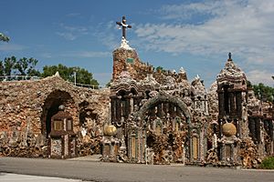
West Bend is home to a very special place called the Grotto of the Redemption. This grotto is made up of nine connected caves. These caves are built using many different kinds of rocks, minerals, and even valuable gems. It covers a whole city block!
Education
Students in West Bend attend schools that are part of the West Bend–Mallard Community School District. This school district was formed in 1995. It happened when the West Bend and Mallard school districts joined together.
Notable Person
- Paul Dobberstein: He was a German American priest and an architect. He is most famous for building the amazing Grotto of the Redemption in West Bend. He lived in West Bend for many years.
See also
 In Spanish: West Bend (Iowa) para niños


