West Branch (New Hampshire) facts for kids
Quick facts for kids West Branch |
|
|---|---|

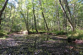
The West Branch at summer low level north of Ossipee Lake
|
|
| Country | United States |
| State | New Hampshire |
| County | Carroll |
| Towns | Madison, Freedom, Ossipee |
| Physical characteristics | |
| Main source | Silver Lake Madison 468 ft (143 m) 43°50′55″N 71°10′17″W / 43.84861°N 71.17139°W |
| River mouth | Ossipee Lake Ossipee / Freedom 407 ft (124 m) 43°48′32″N 71°9′44″W / 43.80889°N 71.16222°W |
| Length | 5.5 mi (8.9 km) |
The West Branch is a short river in eastern New Hampshire, United States. It flows for about 5.5 miles (8.9 kilometers). This river is the main northern stream that feeds into Ossipee Lake.
The West Branch is part of a larger water system. Its waters eventually flow into the Saco River. The Saco River then travels all the way to the Atlantic Ocean.
Contents
Where the West Branch River Starts and Ends
The West Branch river begins at the bottom of Silver Lake. This lake is located in the southern part of Madison, New Hampshire. From there, the river takes a winding path. It flows south until it reaches Ossipee Lake.
River's Journey and Borders
As the West Branch flows, it creates a natural border. It separates the towns of Freedom and Ossipee. This means one side of the river is in Freedom, and the other side is in Ossipee.
Exploring the West Branch Pine Barrens
The area around the West Branch river is quite special. The land is mostly flat and sandy. It is known as the West Branch Pine Barrens. This name comes from the pine trees that grow there.
A Special Nature Preserve
The West Branch Pine Barrens is home to a nature preserve. A nature preserve is a protected area where plants and animals can live safely. This preserve is owned and managed by an organization called The Nature Conservancy. They work to protect important natural places.
 | Claudette Colvin |
 | Myrlie Evers-Williams |
 | Alberta Odell Jones |


