West Decatur, Pennsylvania facts for kids
Quick facts for kids
West Decatur, Pennsylvania
|
|
|---|---|

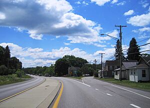
US 322 eastbound in West Decatur
|
|
| Country | United States |
| State | Pennsylvania |
| County | Clearfield |
| Township | Boggs |
| Area | |
| • Total | 1.4 sq mi (3.6 km2) |
| • Land | 1.4 sq mi (3.6 km2) |
| • Water | 0 sq mi (0.0 km2) |
| Elevation | 1,550 ft (470 m) |
| Population
(2020)
|
|
| • Total | 453 |
| • Density | 381/sq mi (147.0/km2) |
| Time zone | UTC-5 (Eastern (EST)) |
| • Summer (DST) | UTC-4 (EDT) |
| ZIP code |
16878
|
| FIPS code | 42-82792 |
| GNIS feature ID | 1211956 |
West Decatur is a small community in Clearfield County, Pennsylvania, United States. It is known as an unincorporated community, which means it's not officially a town or city with its own local government. It's also a census-designated place, meaning the government counts its population for official records. In 2020, about 453 people lived in West Decatur.
About West Decatur
West Decatur is located in the southeastern part of Boggs Township. You can find it along Blue Ball Road, just south of U.S. Route 322. It sits between the towns of Wallaceton and Philipsburg.
Its Original Name
This area was once called Blue Ball. This interesting name came from the blue ball clay found nearby. However, when the local post office was set up, it was given the name West Decatur.
Roads and Railways
West Decatur is on an old road called the Philipsburg and Susquehanna Turnpike. This road was once a main route connecting the big cities of Philadelphia and Erie. Today, it is known as Old Erie Pike.
The community also had a railway line. This was the Clearfield Branch of the Pennsylvania Railroad. It opened in 1868, connecting Philipsburg to Blue Ball. Later, in 1869, the line was extended to Clearfield. The railway line was eventually sold in 1996, but it is no longer used today.
See also
 In Spanish: West Decatur para niños


