West Elizabeth, Pennsylvania facts for kids
Quick facts for kids
West Elizabeth, Pennsylvania
|
|
|---|---|
|
Borough
|
|

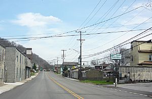
Fifth Street
|
|

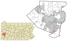
Location in Allegheny County and the U.S. state of Pennsylvania.
|
|
| Country | United States |
| State | Pennsylvania |
| County | Allegheny |
| Area | |
| • Total | 0.24 sq mi (0.63 km2) |
| • Land | 0.18 sq mi (0.46 km2) |
| • Water | 0.07 sq mi (0.17 km2) |
| Population
(2020)
|
|
| • Total | 403 |
| • Density | 2,251.40/sq mi (871.44/km2) |
| Time zone | UTC-5 (Eastern (EST)) |
| • Summer (DST) | UTC-4 (EDT) |
| ZIP codes |
15088
|
| FIPS code | 42-82848 |
West Elizabeth is a small town called a borough in Allegheny County, Pennsylvania, United States. In 2020, about 403 people lived there.
Contents
West Elizabeth: A Look at Its Past
West Elizabeth was first planned out in 1833. It officially became a borough on March 3, 1848.
This town was once a busy place for coal mining and building boats. Coal was a very important resource. It was moved by large boats called barges down the Monongahela River. This coal went to factories in Pittsburgh.
To get the coal from the mines to the river, people used special ramps. These ramps were called Walton's Coal Incline and the O'Neil and Company Incline.
Where is West Elizabeth Located?
West Elizabeth is found at these coordinates: 40°16′22″N 79°53′42″W / 40.27278°N 79.89500°W.
Land and Water in West Elizabeth
The borough covers a total area of about 0.3 square miles. Most of this area, about 0.2 square miles, is land. The rest, about 0.1 square miles, is water. This means about 27.59% of West Elizabeth is covered by water.
Nearby Places
West Elizabeth is located right next to the Monongahela River. On one side, it is surrounded by a place called Jefferson Hills.
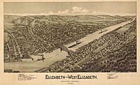
Across the river, West Elizabeth is very close to the borough of Elizabeth. You can easily travel between them using the Malady Bridge.
Who Lives in West Elizabeth?
| Historical population | |||
|---|---|---|---|
| Census | Pop. | %± | |
| 1850 | 328 | — | |
| 1860 | 364 | 11.0% | |
| 1870 | 590 | 62.1% | |
| 1880 | 838 | 42.0% | |
| 1890 | 719 | −14.2% | |
| 1900 | 747 | 3.9% | |
| 1910 | 841 | 12.6% | |
| 1920 | 890 | 5.8% | |
| 1930 | 1,074 | 20.7% | |
| 1940 | 1,297 | 20.8% | |
| 1950 | 1,137 | −12.3% | |
| 1960 | 921 | −19.0% | |
| 1970 | 848 | −7.9% | |
| 1980 | 808 | −4.7% | |
| 1990 | 634 | −21.5% | |
| 2000 | 565 | −10.9% | |
| 2010 | 518 | −8.3% | |
| 2020 | 403 | −22.2% | |
| U.S. Decennial Census | |||
In the year 2000, there were 565 people living in West Elizabeth. These people lived in 247 different homes, and 153 of these were families.
The population density was about 2,764.6 people per square mile. This means a lot of people lived in a small area. There were also 279 housing units, which are places where people can live.
Most people living in the borough in 2000 were White (99.29%). A small number were African American (0.18%), Asian (0.35%), or from two or more races (0.18%).
Households and Families
Out of the 247 homes, about 28.3% had children under 18 living there. About 38.1% were married couples. Some homes (17.4%) had a female head of household with no husband present. About 37.7% were not families.
About 34.0% of homes had only one person living in them. And 13.0% of homes had someone aged 65 or older living alone.
On average, there were 2.29 people in each home. For families, the average size was 2.92 people.
Age and Income
The people in West Elizabeth were spread out in age. About 22.5% were under 18. About 16.8% were 65 or older. The average age was 37 years old.
The median income for a home in the borough was $26,339. For families, it was $32,500. The median income is the middle amount earned.
About 15.5% of all people in West Elizabeth lived below the poverty line. This included 22.1% of those under 18 and 13.1% of those 65 or older.
See also
 In Spanish: West Elizabeth para niños
 | William L. Dawson |
 | W. E. B. Du Bois |
 | Harry Belafonte |


