West Greenwich, Rhode Island facts for kids
Quick facts for kids
West Greenwich, Rhode Island
|
|
|---|---|

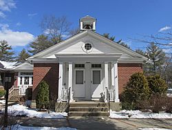
Louttit Library
|
|

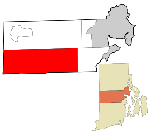
Location in Kent County and the state of Rhode Island.
|
|
| Country | United States |
| State | Rhode Island |
| County | Kent |
| Government | |
| • Type | Five-member Town council |
| Area | |
| • Total | 51.3 sq mi (132.9 km2) |
| • Land | 50.6 sq mi (131.1 km2) |
| • Water | 0.7 sq mi (1.8 km2) |
| Elevation | 472 ft (144 m) |
| Population
(2020)
|
|
| • Total | 6,528 |
| • Density | 129/sq mi (49.8/km2) |
| Time zone | UTC−5 (Eastern (EST)) |
| • Summer (DST) | UTC−4 (EDT) |
| ZIP Code |
02817
|
| Area code(s) | 401 |
| FIPS code | 44-77720 |
| GNIS feature ID | 1220059 |
West Greenwich is a small and friendly town in Rhode Island, United States. It's located in Kent County. In 2020, about 6,528 people lived there.
The town got its name from the historic town of Greenwich, Kent, in England. West Greenwich became its own town in 1741, separating from East Greenwich. Students in West Greenwich attend the Exeter-West Greenwich Regional School.
Contents
Exploring West Greenwich Geography
West Greenwich covers about 51.3 square miles (132.9 square kilometers). Most of this area is land, with only a small part being water.
Natural Features of the Town
One interesting spot in West Greenwich is Escoheag Hill. This hill used to be a place where people could go skiing. Another important natural area is Wickaboxet State Forest, which is also found within the town.
West Greenwich Population History
The number of people living in West Greenwich has changed a lot over the years. Here's a quick look at how the population has grown:
|
||||||||||||||||||||||||||||||||||||||||||||||||||||||||||||||||||||||||||||||||||||||||||||||||||||||||||||
Who Lives in West Greenwich?
In 2000, there were 5,085 people living in West Greenwich. There were 1,749 households, which are groups of people living together in one home. Most of the people living in West Greenwich were White (about 97.7%).
Many households (42.7%) had children under 18 living with them. Most families (72.3%) were married couples. The average household had about 2.9 people.
Age and Income in the Town
The median age in West Greenwich in 2000 was 37 years old. This means half the people were younger than 37 and half were older. About 28.4% of the population was under 18.
The median household income was about $65,725. This means half the households earned more than this amount, and half earned less. A small number of people (4.2%) and families (2.5%) lived below the poverty line.
Historic Places to Visit
West Greenwich has several old and interesting places that are important to its history.
- Louttit Library (built in 1936)
- West Greenwich Baptist Church and Cemetery (built in 1822)
- Stephen Allen House (built in 1787)
- Hopkins Hollow Village (established in 1728)
Images for kids
See also
 In Spanish: West Greenwich para niños


