
West Liberty, Ohio facts for kids
Quick facts for kids
West Liberty, Ohio
|
|
|---|---|
|
Village
|
|

West Liberty's annual antique tractor parade
|
|

Location of West Liberty, Ohio
|
|

Detailed map of West Liberty
|
|
| Country | United States |
| State | Ohio |
| Counties | Logan |
| Townships | Liberty, Monroe |
| Area | |
| • Total | 1.22 sq mi (3.15 km2) |
| • Land | 1.22 sq mi (3.15 km2) |
| • Water | 0.00 sq mi (0.00 km2) |
| Elevation | 1,198 ft (365 m) |
| Population
(2020)
|
|
| • Total | 1,770 |
| • Density | 1,454.40/sq mi (561.47/km2) |
| Time zone | UTC-5 (Eastern (EST)) |
| • Summer (DST) | UTC-4 (EDT) |
| ZIP code |
43357
|
| Area code(s) | 937, 326 |
| FIPS code | 39-83734 |
| GNIS feature ID | 2400135 |
West Liberty is a small village located in Logan County, Ohio, in the United States. In 2020, about 1,770 people lived there.
Contents
History of West Liberty
West Liberty was first planned and settled in 1817. By 1833, the village had grown quite a bit. It had five stores where people could buy things. There were also two taverns, which were like inns or restaurants.
The village also had a tannery, which made leather from animal skins. There was a mill for grinding grain into flour and a saw mill for cutting wood. A "carding machine" helped prepare wool for spinning. At that time, West Liberty had about 20 homes.
Geography and Location
West Liberty covers a total area of about 1.12 square miles (2.9 square kilometers). All of this area is land.
The Mad River flows along the edge of the town. This river is an important source of water for the area.
Population and People
| Historical population | |||
|---|---|---|---|
| Census | Pop. | %± | |
| 1850 | 643 | — | |
| 1860 | 916 | 42.5% | |
| 1870 | 741 | −19.1% | |
| 1880 | 715 | −3.5% | |
| 1900 | 1,236 | — | |
| 1910 | 1,288 | 4.2% | |
| 1920 | 1,347 | 4.6% | |
| 1930 | 1,248 | −7.3% | |
| 1940 | 1,228 | −1.6% | |
| 1950 | 1,397 | 13.8% | |
| 1960 | 1,522 | 8.9% | |
| 1970 | 1,580 | 3.8% | |
| 1980 | 1,653 | 4.6% | |
| 1990 | 1,613 | −2.4% | |
| 2000 | 1,813 | 12.4% | |
| 2010 | 1,805 | −0.4% | |
| 2020 | 1,770 | −1.9% | |
| U.S. Decennial Census | |||
West Liberty in 2010
In 2010, the village had 1,805 people living there. There were 736 households, which are groups of people living together in one home.
Most of the people in West Liberty were White (96.1%). A smaller number were African American (1.3%), Asian (0.6%), or Native American (0.1%). Some people identified as two or more races (1.7%).
About 29.5% of households had children under 18 living with them. Many households (45.9%) were married couples. About 21.2% of households had someone aged 65 or older living alone.
The average age of people in the village was 41 years old. About 25.2% of residents were under 18. Also, 23.2% of residents were 65 years or older.
Transportation in West Liberty
U.S. Route 68 is the main street in West Liberty. It is also known as "Detroit Street."
State Route 245 is the main street that runs east to west. Where US 68 and State Route 245 meet is a very important intersection in the village.
At the northern end of West Liberty, State Route 508 begins. It heads west towards the town of De Graff.
Notable People from West Liberty
- Donn Piatt – a well-known writer and journalist.
- Benjamin Piatt Runkle – one of the people who helped start the Sigma Chi fraternity.
Images for kids
-
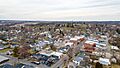
A view of West Liberty in 2021.
.jpg)
See also
 In Spanish: West Liberty (Ohio) para niños
