West Quincy (Quincy, Massachusetts) facts for kids
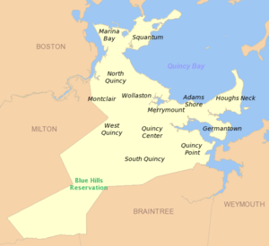
West Quincy is a neighborhood located in the city of Quincy, Massachusetts. It shares its borders with several other areas. To the north, you'll find Wollaston. To the east is Quincy Center, which is a busy part of the city. South of West Quincy is South Quincy. And to the west, it touches the town of Milton and the beautiful Blue Hills Reservation, a large park area.
Getting Around West Quincy
West Quincy has several important roads that help people travel through the area. These main streets include Adams Street, Copeland Street, Furnace Brook Parkway, Quarry Street, and Willard Street.
Highways and Old Railways
Interstate 93, a major highway, runs right through West Quincy. It follows Willard Street and even an old path where the Granite Railway used to be. There are two exits from I-93 that lead directly into West Quincy: Exit 8 at Furnace Brook Parkway and Exit 9 at Bryant Avenue.
Long ago, Massachusetts Route 37 also ran through West Quincy along Willard Street. It used to go all the way to Boston. However, in 1968, the route was changed. Now, Route 37 ends in the town of Braintree.
Bus and Train Connections
If you want to get around using public transport, West Quincy is served by several bus routes. The Massachusetts Bay Transportation Authority (MBTA) operates bus routes 215, 238, and 245 here. These buses can take you to Quincy Center station. From there, you can connect to the subway system or the commuter rail, which are trains that travel to other towns and cities.
 | Madam C. J. Walker |
 | Janet Emerson Bashen |
 | Annie Turnbo Malone |
 | Maggie L. Walker |


