
West Thurrock Power Station facts for kids
Quick facts for kids West Thurrock Power Station |
|
|---|---|

West Thurrock Power Station, 1973.
|
|
| Country | England |
| Location | Essex, East of England |
| Coordinates | 51°28′10″N 0°17′20″E / 51.469573°N 0.288756°E |
| Status | Decommissioned and demolished |
| Construction began | 1957 |
| Commission date | 1962 |
| Decommission date | 1993 |
| Owner(s) | As operator |
| Operator(s) | Central Electricity Generating Board (1962–1990) National Power (1990–1993) |
| grid reference TQ589770 | |
West Thurrock Power Station was a big factory that used coal to make electricity. It was located right next to the River Thames in a place called West Thurrock, in Essex, England. This power station was also connected to the National Grid, which is like a huge network that delivers electricity all over the country.
Contents
Building the Power Station
The West Thurrock Power Station was built by a group called the Central Electricity Generating Board. Unlike many other power stations along the River Thames, this one was built on a brand new, empty piece of land. This land was about 37 hectares, which is like 70 football fields!
Building the station took several years. Work started in 1957 and finished in 1965. The area near the river was marshy, so they had to do a lot of piling and filling the land first. Even though it took a while to finish, the first machine that made electricity started working in 1962.
How West Thurrock Power Station Worked
West Thurrock was designed to be very powerful. It could produce 1300 megawatts (MW) of electricity, which was a lot for its time. It was one of the first power stations built by the CEGB that could make over 1000 MW.
The station had five large machines called generators. Two of these generators could make 200 MW each, and they started working in 1962 and 1963. The other three generators were even bigger, making 300 MW each, and they started in 1964 and 1965.
The power station used huge boilers to heat water and create steam. These boilers were special because they were open to the outside air. They were first designed to burn pulverised coal, which is coal ground into a fine powder. Later, between 1971 and 1980, they were changed to burn natural gas. In 1985, they also added the ability to burn heavy fuel oil.
The station had two very tall chimneys, each about 175 meters high. That's taller than many skyscrapers! These chimneys were made of strong concrete. A cool fact is that the ash left over from burning coal was sold to a local factory. This factory then used the ash to make building blocks.
The End of West Thurrock Power Station
In 1989, the way electricity was supplied in the United Kingdom changed. The power stations, including West Thurrock, were taken over by private companies. West Thurrock was then run by a company called National Power.
In 1992, one of the station's generators was stopped. The next year, in 1993, the other four generators were also stopped, and the power station closed down completely. When it closed, there was a huge pile of coal left over. This coal was moved by special boats to another power station nearby called Tilbury Power Station.
After the power station was taken apart, some of the land was used for new purposes. Part of it became a factory that makes chemicals. There was also a plan to build a large mail sorting office on the land where the coal ash used to be. However, this idea caused some discussion because many animals and plants had started living there.
An interesting thing you can still see at the site are the giant pylons. These are part of the 400 kV Thames Crossing, which is a power line that crosses the River Thames.
How Much Electricity Was Made?
The graph below shows how much electricity West Thurrock Power Station produced each year from 1964 to 1987. The numbers are in GWh, which stands for gigawatt-hours – a way to measure a lot of electricity!
West Thurrock annual electricity output GWh.<graph>{ "version": 2, "width": 700, "height": 300, "data": [ { "name": "table", "values": [ { "x": 1964, "y": 1043 }, { "x": 1965, "y": 1987 }, { "x": 1966, "y": 2824 }, { "x": 1967, "y": 3197 }, { "x": 1968, "y": 4883 }, { "x": 1969, "y": 4662 }, { "x": 1970, "y": 4068 }, { "x": 1971, "y": 3433 }, { "x": 1972, "y": 3153 }, { "x": 1973, "y": 4831 }, { "x": 1974, "y": 6659 }, { "x": 1975, "y": 7755 }, { "x": 1976, "y": 8492 }, { "x": 1977, "y": 5858 }, { "x": 1978, "y": 6482 }, { "x": 1979, "y": 5011 }, { "x": 1980, "y": 4595 }, { "x": 1981, "y": 4264 }, { "x": 1982, "y": 3208 }, { "x": 1983, "y": 3622 }, { "x": 1984, "y": 3102 }, { "x": 1987, "y": 3052 }, { "x": 1963, "y": 202 } ] } ], "scales": [ { "name": "x", "type": "ordinal", "range": "width", "zero": false, "domain": { "data": "table", "field": "x" } }, { "name": "y", "type": "linear", "range": "height", "nice": true, "domain": { "data": "table", "field": "y" } } ], "axes": [ { "type": "x", "scale": "x" }, { "type": "y", "scale": "y" } ], "marks": [ { "type": "rect", "from": { "data": "table" }, "properties": { "enter": { "x": { "scale": "x", "field": "x" }, "y": { "scale": "y", "field": "y" }, "y2": { "scale": "y", "value": 0 }, "fill": { "value": "steelblue" }, "width": { "scale": "x", "band": "true", "offset": -1 } } } } ] }</graph>
Images for kids
-
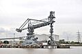
A bulk unloader from the power station still in use at West Thurrock Jetty, 2010

