
West Union Covered Bridge (Indiana) facts for kids
Quick facts for kids West Union Covered Bridge |
|
|---|---|

West Union Covered Bridge
|
|
| Coordinates | 39°51′17.75″N 87°20′8.75″W / 39.8549306°N 87.3357639°W |
| Carries | Tow Path Road (C.R. 525W) |
| Crosses | Sugar Creek, Parke County, Indiana |
| Locale | Parke, Indiana, United States |
| Official name | West Union Covered Bridge |
| Named for | West Union, Indiana |
| Maintained by | Parke County |
| WGCB Number |
|
| Characteristics | |
| Design | National Register of Historic Places |
| Total length | 337 ft (103 m)310ft +10ft +17ft overhangs on each end |
| Width | 17 ft (5.2 m) |
| Height | 14.5 ft (4.4 m) |
| History | |
| Designer | J. J. Daniels |
| Constructed by | J. J. Daniels |
| MPS | Parke County Covered Bridges TR |
| NRHP reference No. | 78000414 |
| Added to NRHP | Dec 22, 1978 |
| Lua error in Module:Location_map at line 420: attempt to index field 'wikibase' (a nil value). | |
The West Union Covered Bridge is a special old bridge near Montezuma, Indiana. It was built in 1876 by Joseph J. Daniels. This bridge is famous because it's the longest covered bridge still standing in Parke County. It's also one of the best examples of a "Burr Arch Truss" design in the whole country.
Because it's so important, it was listed on the National Register of Historic Places in 1978. Later, in 2016, it was even named a National Historic Landmark!
A Look Back: Bridge History
The West Union Covered Bridge is actually the third bridge to be built in this spot. The first bridge was called the Star Mill Covered Bridge. Then, the Harrison Covered Bridge replaced it. But the Harrison bridge got damaged in 1876. That's why the West Union Covered Bridge was built. It was finished in September 1876.
The road over the bridge was once part of the "Indiana State Highway." This highway was created in 1827. It connected the cities of Fort Wayne and Terre Haute. The West Union Bridge, along with the Armiesburg Covered Bridge, was used by stagecoaches traveling to Lafayette.
West Union Town
Not much is left of the old town of West Union today. You can only find a few houses there now. The school, post office, and railroad are all gone.
The Wabash and Erie Canal used to run just west of the town. There was also a smaller canal that connected to Sugar Creek, west of the bridge. The Chicago & Eastern Illinois Railroad also crossed Sugar Creek to the east of the bridge. It then passed West Union on the west side. Today, there's not much left to show where the railroad or canal once were. Farmers now use most of that land for their crops.
Gallery
-
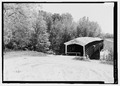
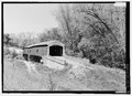
View of Northwest portal.
-
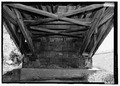
Detail of Southeast abutment with view of double Burr Arch rings bearing on abutment and lower truss details.
-
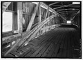
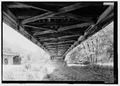
Interior view of double Burr Arches, Kings Posts, and upper truss.
-
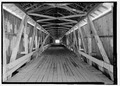
View looking Southeast of interior of bridge.
-
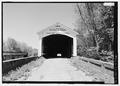
View of Southeast portal. (Note new bridge to far left)
-
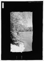
View out of east window looking east.
-
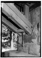
Detail of Southeast of abutment.
-
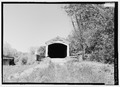
View of Southeast portal.
-
View of center abutment from Southeast abutment.
-
View of Southwest side of bridge from South.
-
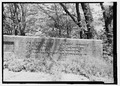
Detail of wall inscription showing 1914 date and names of county officials at time of building.
-
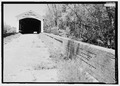
View of wall, built in 1914 after flood damaged original walls, and Southeast portal.
