
West View, Pennsylvania facts for kids
Quick facts for kids
West View, Pennsylvania
|
|
|---|---|
|
Borough
|
|
| Borough of West View | |

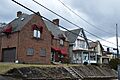
Houses on Ridgewood Avenue
|
|
| Motto(s):
A Good Place to Live
|
|

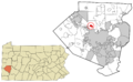
Location in Allegheny County and the U.S. state of Pennsylvania.
|
|
| Country | United States |
| State | Pennsylvania |
| County | Allegheny |
| Founded by | Frederick Christian Martsolf |
| Area | |
| • Total | 1.01 sq mi (2.62 km2) |
| • Land | 1.01 sq mi (2.62 km2) |
| • Water | 0.00 sq mi (0.00 km2) |
| Population
(2020)
|
|
| • Total | 6,685 |
| • Density | 6,451.49/sq mi (2,491.67/km2) |
| Time zone | UTC-5 (EST) |
| • Summer (DST) | UTC-4 (EDT) |
| ZIP code |
15229
|
| Area code(s) | 412 |
| School district | North Hills |
West View is a small town, also known as a borough, in Allegheny County, Pennsylvania. It's located just north of Pittsburgh, a big city in the United States. In 2020, about 6,685 people lived here. West View is considered a suburb of the Pittsburgh metropolitan area, meaning it's a residential area close to the main city.
Contents
Exploring West View's Location
West View is found at coordinates 40°31′6″N 80°2′1″W / 40.51833°N 80.03361°W. This helps us pinpoint its exact spot on a map.
The United States Census Bureau tells us that West View covers about 1.0 square mile (2.6 square kilometers) of land. There's no water area within the borough.
A Look at West View's Past
West View became an official borough on March 20, 1905. In the early 1900s, a company called Allegheny-Bellevue Land Company started buying land in Ross Township. Their goal was to build new homes.
How West View Got Its Name
A land developer named Frederick Christian Martsolf really liked the area. He worked with the land company to create West View Borough. It covered 640 acres right in the middle of Ross Township. West View held its first election on May 16, 1905. Martsolf was chosen as the first president of the Borough Council on May 24, 1905.
People say the name "West View" came from early travelers. These pioneers were heading north from Pittsburgh on a path called the Venango Trail. They loved the view they saw looking to the west. The Venango Trail was an old path used by Native Americans for hundreds of years before European settlers arrived. It started in Pittsburgh and went all the way north to Erie, PA. Today, U.S. Route 19, a major road that runs through West View, follows the same path as the old Venango Trail.
Early Settlers in West View
Casper Reel was the first European settler in the West View and Ross area. He was born in Frankfurt, Germany in 1742 and moved to America around 1761. After fighting in the Continental Army during the Revolutionary War, Reel received 727 acres of land. This land was in what was then called Pine Township.
Reel built his first cabin in West View in 1792. However, he had to leave soon after because of attacks from Native Americans. He didn't return until 1795. That's when he built a second cabin, which you can still see in the borough today! Reel became a successful farmer. He was also the first tax collector north of Pittsburgh. He passed away in 1824. Most of the land that makes up West View today was once owned by Casper Reel.
Learning in West View
Students in West View attend schools in the North Hills School District. This district also serves the neighboring Ross Township.
West View Park: A Fun Place from the Past
From 1906 to 1977, West View was home to a very famous amusement park called West View Park. Many people in Pittsburgh remember it fondly. Theodore Marshall Harton II came up with the idea for the park. In 1905, he leased 18.42 acres of land in the new West View Borough. The park was perfectly located at the end of the Bellevue/West View trolley line, making it easy for visitors to get there. West View Park first opened its gates on May 23, 1906.
Rides and Entertainment
This "trolley park" had a main pathway with many attractions. It featured two popular roller coasters:
- The Dips: This coaster had a special banked turn that made it unique.
- The Racing Whippet: This ride had two coasters on a single track. They were set up so that a train starting on the left side of the platform would return on the right side, and vice versa!
Another very popular spot at the park was "Danceland." This was a large hall where many different performers played music. From big bands to rock and roll groups, Danceland hosted them all. A very famous band, The Rolling Stones, even performed there in 1964. Sadly, Danceland burned down in 1973 and was never rebuilt.
The Park's Closing
West View Park closed for good after the 1977 season. A competing amusement park, Kennywood, was always adding bigger and newer rides. West View Park couldn't do the same because of its smaller size and location. Today, the West View Park Shopping Center stands where the amusement park used to be. The shopping center opened in 1981. You won't find any traces of the old park there now. However, some nearby businesses display old items like signs, photos, and tickets from the park.
The book Stick Man, which is about a boy growing up in a unique family, is set in West View. Several important parts of the story happen at West View Park. The book was written by Richard Rossi, who grew up in West View.
Images for kids
-
Houses on Ridgewood Avenue
-
Location in Allegheny County and Pennsylvania
See also
 In Spanish: West View (Pensilvania) para niños
