West Wood, Utah facts for kids
Quick facts for kids
West Wood, Utah
|
|
|---|---|

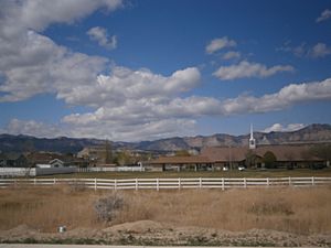
The local meetinghouse of the Church of Jesus Christ of Latter-day Saints, a landmark in central West Wood.
|
|

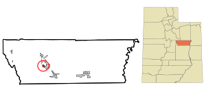
Location in Carbon County and the State of Utah
|
|
| Country | |
| State | |
| County | Carbon |
| Developed | 1975 |
| Area | |
| • Total | 1.0 sq mi (2.7 km2) |
| • Land | 1.0 sq mi (2.7 km2) |
| • Water | 0 sq mi (0.0 km2) |
| Elevation | 5,617 ft (1,712 m) |
| Population
(2020)
|
|
| • Total | 1,066 |
| • Density | 795/sq mi (307.0/km2) |
| Time zone | UTC-7 (Mountain (MST)) |
| • Summer (DST) | UTC-6 (MDT) |
| ZIP code |
84501
|
| Area code(s) | 435 |
| GNIS feature ID | 2584782 |
West Wood is a small community in Carbon County, Utah, United States. It is known as a census-designated place (CDP). This means it is an area that the government counts for the census, but it is not officially a city or town. In 2020, about 1,066 people lived there.
Contents
Where is West Wood Located?
West Wood is found just west of Price. Price is the main city in Carbon County. To the north and northeast of West Wood, you'll find Carbonville. These two areas are separated by U.S. Route 6, a major road.
The Carbon County Fairgrounds are located to the south of West Wood. To the west, you can see natural areas like Pinnacle Canyon and Porphyry Bench. These are part of the Wasatch Plateau, a large mountain area.
Streets and Waterways
Important streets in West Wood include Fairgrounds Road and Westwood Boulevard. Westwood Boulevard goes east under the highway. It then becomes Utah State Route 55 and 100 North in Price.
Two waterways flow through West Wood. One is Pinnacle Creek. The other is the Carbon Canal, which is privately owned. This area naturally has a lot of water underground. Because of this, people living in West Wood sometimes have problems with flooding.
The total area of West Wood is about 2.7 square kilometers. This entire area is land, with no large bodies of water.
How West Wood Grew
For a long time, the land west of Price was mostly empty countryside. This changed in 1975. That's when the "Westwood" neighborhood began to be built. This was the start of the community we know today as West Wood.
More people started to move to West Wood after 1980. This was when Castleview Hospital opened its doors nearby. Over the years, more neighborhoods have been built. Planning for West Wood's future is an important topic for the government in Carbon County.
Who Lives in West Wood?
| Historical population | |||
|---|---|---|---|
| Census | Pop. | %± | |
| 2010 | 844 | — | |
| 2020 | 1,066 | 26.3% | |
In 2010, there were 844 people living in West Wood. They lived in 258 homes. Out of these homes, 225 were families. By 2020, the population had grown to 1,066 people.
Most of the people in West Wood are White, making up about 96.7% of the population in 2010. A small number of people were American Indian, Alaska Native, Asian, or Native Hawaiian and Pacific Islander. About 1.1% were from other backgrounds. About 1.2% of people identified with two or more races. About 6.3% of the population was Hispanic or Latino.
Families and Age
Many homes in West Wood have children. In 2010, about 48.1% of homes had children under 18 living there. Most homes, about 78.7%, had married couples living together.
The average home in West Wood had about 3.27 people. The average family had about 3.58 people. About 53.1% of the population was male. The median age, which is the middle age of all the people, was 33.7 years old.
See also
 In Spanish: West Wood (Utah) para niños
 | Delilah Pierce |
 | Gordon Parks |
 | Augusta Savage |
 | Charles Ethan Porter |

