Western Addition, San Francisco facts for kids
Quick facts for kids
Western Addition
|
|
|---|---|

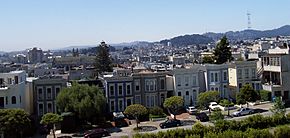
A southern view from Alta Plaza Park, which is in the Pacific Heights neighborhood. Most of the valley in the central part of this image is in the Western Addition neighborhood.
|
|
| Country | United States |
| State | California |
| Area | |
| • Total | 0.463 sq mi (1.20 km2) |
| • Land | 0.463 sq mi (1.20 km2) |
| Population
(2008)
|
|
| • Total | 12,934 |
| • Density | 27,919/sq mi (10,780/km2) |
| ZIP Code |
94102, 94109, 94115, 94117
|
| Area codes | 415/628 |
The Western Addition is a neighborhood in San Francisco, California, United States.
Contents
Where is the Western Addition?
The Western Addition is located in San Francisco. It sits between several other neighborhoods. These include Van Ness Avenue, the Richmond District, Haight-Ashbury, Lower Haight, and Pacific Heights.
Different Ways to Define the Area
People use the name "Western Addition" in two main ways today.
- Sometimes it means the original large area it covered.
- Other times, it refers to just the eastern part of the neighborhood. This eastern part is also known as the Fillmore District. It was rebuilt in the 1950s.
If you use the first meaning, the Western Addition's borders are:
- East: Van Ness Avenue
- West: Masonic Street
- North: California Street
- South: Fell or Oak Street
This larger area is then divided into smaller neighborhoods. Some of these are Lower Pacific Heights, Cathedral Hill, Japantown, the Fillmore, Hayes Valley, Alamo Square, Anza Vista, and North Panhandle.
The San Francisco Association of Realtors has a different definition. They call it "District 6D." This area is mostly the same as the Fillmore and Cathedral Hill neighborhoods. Its borders are:
- North: Geary Boulevard
- South: McAllister and Fulton streets, and Golden Gate Avenue
- East: Van Ness Avenue
- West: Divisadero Street
History of the Western Addition
The Western Addition was first planned in the 1850s. This happened because of something called the Van Ness Ordinance. This plan created about 500 city blocks. They stretched west from Larkin Street, which was the city's old western edge, to Divisadero Street. That's why it was called the "Western Addition."
The plan also created several parks and squares. These include Jefferson Square, Hamilton Square, Alamo Square, Alta Plaza, and Lafayette Square.
From Farms to Homes
At first, the area was used for small farms. But in the 1870s, the cable car was invented. This made it easier to travel around the city. So, the Western Addition grew into a neighborhood with many homes. It became known for its beautiful Victorian-style buildings.
When the 1906 San Francisco earthquake hit San Francisco, many parts of the city were destroyed. But the Western Addition's Victorian buildings were mostly saved.
Changes After World War II
After Second World War, many African-American families moved to San Francisco. The Western Addition, especially the Fillmore District, became a key place for this community. This was partly because housing became available after Japanese Americans were moved to internment camps during the war.
Over time, city plans to rebuild parts of the area, called urban renewal, changed the neighborhood. The people living there and the types of businesses also changed. The Fillmore District faced challenges, while other areas nearby became more expensive and popular.
The Central Freeway used to run through the neighborhood. But a part of it was closed after the 1989 Loma Prieta earthquake. That section was later taken down.
Since the early 1990s, the Western Addition has continued to change. Many parts of the neighborhood have become more developed and modern.
Famous Buildings in the Western Addition
The Western Addition is home to several important and historic buildings. Many of these are recognized for their history and architecture.
- Building at 1840–1842 Eddy Street: This house was built in 1875. It is listed as a California Historical Landmark.
- Building at 1813–1813B Sutter Street: Built in 1876, this building was used for homes and businesses. It is also a California Historical Landmark.
- Building at 1735–1737 Webster Street: This building was constructed between 1876 and 1885. It is recognized as a California Historical Landmark.
- Bush Street–Cottage Row Historic District: This area includes 20 historic homes, a walkway, and a small park. It is a San Francisco Designated Landmark.
- Goodman Building: Built around 1860, this building was once a hotel and business space. It was also a place where artists lived and worked.
- Japanese YWCA/Issei Women’s Building: Founded in 1912 by Issei Japanese women. They started it because Japanese women were not allowed to use the main San Francisco YWCA. It is a San Francisco Designated Landmark.
- Stadtmuller House: Built in 1880, this house has a very detailed design. It shows the Italianate style from the late 1800s. It is a San Francisco Designated Landmark and a California Historical Landmark.


