Westport Canal facts for kids
Quick facts for kids Westport Canal |
|
|---|---|

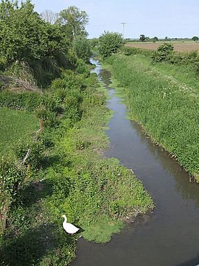
The old Westport Canal near Westport.
|
|
| Specifications | |
| Locks | 1 + a flood gate |
| Status | Derelict |
| History | |
| Original owner | Parrett Navigation Company |
| Principal engineer | William Gravatt |
| Date of act | 1836 |
| Date of first use | 1840 |
| Date closed | 1875 |
| Geography | |
| Start point | Westport |
| End point | Muchelney |
| Branch of | River Parrett |
The Westport Canal was a waterway built in the late 1830s. It connected the village of Westport to Langport in Somerset, England. This canal was part of a bigger plan to make the River Parrett easier to travel on, especially above Burrow Bridge. Langport is where the River Yeo joins the River Parrett. The main goal was to help boats carry goods to and from the port at Bridgwater.
The canal was used until the 1870s. It closed when a group called the Somerset Drainage Commissioners took control of the River Parrett. Even though local people asked for the canal to stay open, the Commissioners decided it had to close. They believed the law that gave them control meant all boat traffic had to stop. Since 1878, the canal has mainly been used to help drain water from the land.
Even today, the canal channel still exists because it helps with drainage. Many of the old buildings and structures from the canal's past can still be seen. Some of these are even on the listed building register, which means they are important historical sites. There is also some interest in making the canal better for people to enjoy, perhaps for activities like canoeing.
Contents
The Westport Canal: A Waterway's Story
Building the Canal
Why Was It Built?
By the 1830s, Westport village was well-connected by roads. New roads had been built in 1753, 1759, and 1823. These roads linked Westport to nearby towns like Ilminster and Chard. There was also a plan for another canal, the Chard Canal, to connect these towns to Taunton. People planning the Westport Canal even asked if they could link their canal to the Chard Canal, but this idea was turned down.
At this time, people wanted better ways to move goods. So, they decided to build the Westport Canal. They hired a famous engineer, Isambard Kingdom Brunel, to give advice.
How It Was Built
Building the Westport Canal was approved by a special law from Parliament in 1836. This law allowed a new company, the Parrett Navigation Company, to raise money. They could get £10,500 by selling shares. If needed, they could borrow another £3,300.
The canal was part of a larger project. The law also allowed improvements to the River Parrett between Burrow Bridge and Langport. They also rebuilt the river bridge at Langport. This bridge had made it hard for boats to travel further upriver for many years. Two local landowners, the Trevillian and Combe families, supported the project. This made it easy to get the land needed for the canal.
Brunel suggested that William Gravatt should be the main engineer for the whole project. Gravatt had worked with Brunel before on the Bristol and Exeter Railway. Charles Hodgkinson helped Gravatt locally. The first work on the River Parrett cost more than expected. So, another law was passed in 1839. This allowed the company to raise an extra £20,000 and charge more for using the canal. Some local business owners tried to stop the price increase. But a petition they sent to Parliament was found to be fake.
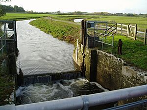
The canal started from Langport and followed the River Parrett. At the point where the River Isle joined, a lock was built. This lock helped keep the water levels steady on the River Isle. About 1.6 kilometers (1 mile) further upstream, the canal turned off towards Westport. In Westport, five wharfs (places for boats to load and unload) and a basin (a wider area for boats) were built. A special half-lock at the start of the canal protected it from high river levels. Gravatt designed clever "self-acting" flood gates for the project.
The canal officially opened on May 20, 1839. However, some business owners complained about low water levels. More work was needed to clear mud from the river section. The whole project was finished in 1840. At first, the canal made good money. The Westport end of the canal had two warehouses, a coal yard, and an office. Even after the Chard Canal opened in 1842, one company, Stukey and Bagehot, paid tolls for over 10,402 tons of goods in 1843. The main things carried were coal, brought to villages, and grain, sent out from the area. Other goods included timber coming in and stone and reeds going out.
Life of the Canal
Busy Times and Trade
For a while, the Westport Canal was very busy. Boats carried important goods like coal, which was used for heating and power. They also carried grain, which was grown in the area and sent to other places. Timber was brought in and stored, while stone and reeds were sent out. The canal helped local businesses grow and connected the area to the wider world through the port at Bridgwater.
The Railway Arrives
However, a new way of transport arrived: the railway. A railway line from Durston to Yeovil started being built in 1847 and finished in 1853. Before 1853, the canal made over £1,400 each year. But by 1857, this had dropped to £673. By 1871, it was only £347. In 1858, a lot of work was needed to clear reeds and mud from the canal. This made the canal lose money. Another railway line opened through Ilminster and Chard in 1866. More and more trade moved from the canal to the railways.
Why the Canal Closed
In 1875, there was flooding in Westmoor. Local landowners opened Langport Lock on the River Parrett. This was because the canal company could not afford to fix a broken culvert (a pipe carrying water under the river). With the lock open, the canal company could not charge tolls.
A new law, the Somersetshire Drainage Bill, was changed. It allowed the Somerset Drainage Commissioners to take over the entire River Parrett Navigation for free. This law became official on July 1, 1878. The law said the Commissioners could close any waterways they controlled. They understood this to mean all waterways must be closed. In 1880, people who used the Westport Canal asked for it to stay open. But they were told the Drainage Commissioners did not have the power to allow this. So, the canal stopped being used for boats from 1875. From 1878, it was used only as a drain for the Somerset Levels.
The Canal Today
Exploring the Route
The Westport Canal still holds water today. Small boats like canoes can travel on it, though you have to carry them past Midelney lock. In the 1970s, some repairs were done by Wessex Water Authority. Midelney lock is now broken down. The Westmoor Lane bridge at Hambridge has been made lower, which means boats cannot pass under it. However, the bridge at the entrance to the Westport wharfs has been fixed up. The old warehouse buildings there have also been repaired.
There is a lot of local interest in making the canal better for people to enjoy. Some hope that small boats might even be able to use it again in the future.
Old Buildings and Bridges
The canal ended at Westport, and many of its old structures are still there. The square, three-story warehouse, built in 1836, faced the canal basin. It is now a grade II listed building, and part of it is used as a house. The old timber store, also built in 1836, is now an industrial workshop. Two semi-detached cottages, where canal workers used to live, are still near the canal basin entrance.
The bridge at the basin entrance carries a path called Barrington Broadway over the canal. It was built from local stone and has one arch. A little further along, an almost identical bridge carries Knighton Drove over the canal. The B3168 road from Westport to Curry Rivel runs along the west bank of the canal for a while. Then, the road and canal separate. A footbridge takes the towpath (the path next to the canal) to the east bank. The canal then passes to the east of Hambridge.
Near Hambridge, the towpath crosses back to the west bank. After that, Westmoor bridge crosses the canal. This bridge has been lowered, so boats cannot pass. Just before the River Isle joins from the west, Middlemoor bridge takes the towpath back to the east bank. The towpath stays on this side until Midelney Bridge. This is another grade II listed building and carries a small road to Midelney Manor. Midelney Manor is a grade I listed building and was built on what was once an island owned by Muchelney Abbey. Much of it dates back to the 1500s. Below the bridge, the Southmoor main drain runs next to the canal, with the towpath in between them. Finally, you reach the broken-down Midelney lock. Close by is Midelney pumping station, built in the 1960s.
 | Selma Burke |
 | Pauline Powell Burns |
 | Frederick J. Brown |
 | Robert Blackburn |


