Westville Dam facts for kids
Quick facts for kids Westville Dam |
|
|---|---|

Westville Lake and Dam
|
|
| Official name | Westville Dam |
| Location | Southbridge and Sturbridge, Massachusetts |
| Coordinates | 42°04′54″N 72°03′28″W / 42.08167°N 72.05778°W |
| Construction began | June 1960 |
| Opening date | August 1962 |
| Operator(s) | Army Corps of Engineers |
| Dam and spillways | |
| Impounds | Quinebaug River |
| Height | 78 ft (24 m) |
| Length | 560 ft (170 m) |
| Width (crest) | 25 ft (7.6 m) |
| Reservoir | |
| Creates | Westville Lake |
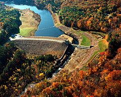
The Westville Dam is a large dam in Massachusetts, USA. It is located on the Quinebaug River. You can find it between the towns of Southbridge and Sturbridge. It is about 1.3 miles (2.1 km) west of Southbridge.
The Army Corps of Engineers designed and built this dam. Its main job is to greatly reduce flooding. It protects areas along the Quinebaug and Thames rivers. Building the dam started in June 1960. It was finished in August 1962. The total cost was about $5.6 million.
The Westville reservoir is part of the Quinebaug River Watershed. This area also belongs to the Thames River Basin. You can get to the dam easily. It is close to Interstate 84 and State Route 131.
Contents
About the Westville Dam
| Westville Dam bridge | |
|---|---|
| Carries | Dam service road / Westville Community trail |
| Characteristics | |
| Width | One lane |
| Clearance above | Unrestricted |
| Statistics | |
| Daily traffic | < 10 vehicles |
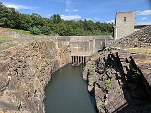
The Westville Dam is made of earth and has stone on its slopes. It is 560 feet (171 m) long and 78 feet (24 m) high. The dam has a special part called a spillway. This concrete spillway is 200 feet (61 m) long. It helps control water flow.
The top of the spillway is 15 feet (4.6 m) lower than the top of the dam. The dam creates a permanent lake called Westville Lake. This lake is 23 acres (9.3 ha) big. Its deepest part is about 16 feet (4.9 m).
The area where floodwater can be stored is very large. It covers about 913 acres (3.7 km²) in Southbridge and Sturbridge. The entire dam project, including all its lands, covers 510 acres (206 ha). The Westville Dam can hold a huge amount of water. It can store up to 3.61 billion US gallons (13.7 million m³) for flood control. This is like having 6.5 inches (165 mm) of water covering its drainage area. That area is 32 square miles (83 km²).
Fun Things to Do at Westville Lake
There are many fun activities at Westville Lake. You can find a large picnic and recreation area here. It has two picnic shelters you can reserve. These are near the south end of the lake. The entrance is on Wallace Road in Sturbridge. It is close to the Quinebaug River bridge.
There is also a boat ramp in the recreation area. Please note that camping and swimming are not allowed. There is no fee to enter the recreation area. It is open every day during the summer season. This season runs from the third Saturday in May to the second Sunday in September. The hours are from 8 AM to 8 PM.
Trails for Exploring
There is a 1.8-mile (2.9 km) loop trail around the lake. It is called the Westville Lake Community Trail. You can use it for walking, running, or biking. No motorized vehicles are allowed on this trail. You can get onto the trail from a few places. These include the recreation area, the dam's parking lot, and the Wallace Road trailhead.
Another path is the Heritage Trail. This walking trail starts at the dam. It goes north along the river. It leads to the nearby West Street School.
The Grand Trunk Trail is also nearby. This trail follows an old railway line that was never finished. It goes 1.1 miles (1.8 km) from the recreation area to River Road in Sturbridge. Part of the Community Trail loop also uses this old railway path. All the trails and parking areas are open all year. They are open from sunrise to sunset.
Boating and Fishing
You can find a special area for launching canoes and fishing. It is located along Old Mashapaug Road. This is west of the main recreation area. Canoeists can paddle up the Quinebaug River. You can go as far as Turner's Club Field in Fiskdale village. This is about 5 miles (8 km) upstream. Old Mashapaug Road is open for cars during daylight hours. It is open from the start of fishing season in April. It closes on the Sunday after Labor Day.
There is also a 3/4-mile (1.2 km) trail in the Hobbs Brook area. You can find the start of this trail off Hall Road in Sturbridge.


