Wheatfield Road facts for kids
Quick facts for kids Wheatfield Road |
|
|---|---|

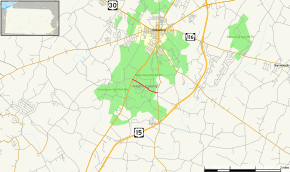
Map of Adams County in southern Pennsylvania with Wheatfield Road highlighted in red
|
|
| Route information | |
| Maintained by National Park Service | |
| Length | 1.20 mi (1.93 km) |
| Time period | 1858 mapped by Howe 1863 Battle of Gettysburg 1895 Gettysburg National Military Park 1933 National Park Service |
| Major junctions | |
| West end | |
| East end | |
| Location | |
| Counties: | Adams |
| Highway system | |
| Roads in Pennsylvania Interstate • US • State • Legislative |
|
The Wheatfield Road is a special road located in the Gettysburg Battlefield in Pennsylvania. It stretches from the area known as the Peach Orchard towards the east. This road runs along the northern side of a famous battle area called The Wheatfield. It also passes north of the Valley of Death and the base of Little Round Top.
Today, people use Wheatfield Road to visit the battlefield. But it's also important because of its role in the Battle of Gettysburg in 1863. Later, an electric trolley line used part of the road. This trolley was even part of a big court case that went all the way to the US Supreme Court in the 1890s.
What You See on Wheatfield Road
Wheatfield Road starts in Cumberland Township. It begins where it meets US 15 Bus. inside the Gettysburg National Military Park. From this point, the road continues west as Millerstown Road.
As you travel east-southeast, Wheatfield Road is a two-lane road without a divider. It goes through open fields that are part of the park. Further along, the road enters wooded areas, still with some fields around. It passes to the north of the famous Little Round Top hill.
Wheatfield Road ends when it meets PA 134 in a small community called Round Top. From there, the road keeps going east as Blacksmith Shop Road, leading to Baltimore Pike.
Wheatfield Road's Past
During the Battle of Gettysburg, Wheatfield Road was just a dirt path. Both Union and Confederate soldiers used it. For example, Union troops moved their cannons along this road to the Peach Orchard.
Years after the battle, in 1884, a train station and tracks were built near the east end of Wheatfield Road. Then, in 1894, the Gettysburg Electric Railway laid trolley tracks along a western part of the road. Trolleys also crossed the eastern end near Round Top Station.
In 1895, the state of Pennsylvania gave control of Wheatfield Road to the War Department (which managed military matters). By 1900, two metal signs were put up to help people identify the road. The trolley tracks were removed from Wheatfield Road in 1917. The road itself was repaired in 1931. It was paved with asphalt in 1933 and finished being paved in 1940 by workers from the Civilian Conservation Corps.
 | Audre Lorde |
 | John Berry Meachum |
 | Ferdinand Lee Barnett |

