Wheatley Heights, New York facts for kids
Quick facts for kids
Wheatley Heights, New York
|
|
|---|---|

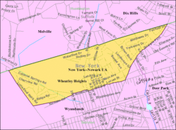
U.S. Census map
|
|
| Country | United States |
| State | New York |
| County | Suffolk |
| Area | |
| • Total | 1.32 sq mi (3.41 km2) |
| • Land | 1.32 sq mi (3.41 km2) |
| • Water | 0.00 sq mi (0.00 km2) |
| Elevation | 102 ft (31 m) |
| Population
(2020)
|
|
| • Total | 5,140 |
| • Density | 3,899.85/sq mi (1,505.92/km2) |
| Time zone | UTC-5 (Eastern (EST)) |
| • Summer (DST) | UTC-4 (EDT) |
| ZIP code |
11798
|
| Area code(s) | 631 |
| FIPS code | 36-81419 |
| GNIS feature ID | 1867425 |
Wheatley Heights is a special kind of community in Suffolk County, New York. It's called a census-designated place (CDP). This means it's an area identified by the U.S. Census Bureau for statistics, but it's not an officially incorporated town or village. In 2020, about 5,140 people lived here. Wheatley Heights is located within the Town of Babylon.
Contents
History of Wheatley Heights
Wheatley Heights used to be part of a nearby community called Wyandanch. They still share the same ZIP code and fire department. The name "Wheatley Heights" was chosen by the Postmaster of Wyandanch, Thomas A. Brown.
Around 2001, there was an idea to combine Wheatley Heights with some neighboring areas. These areas included Dix Hills, East Farmingdale, and Melville. The plan was to create one big village called the "Incorporated Village of Half Hollow Hills." However, this plan didn't happen. All these communities remain unincorporated, meaning they are not official villages or towns.
Geography and Location
Wheatley Heights is a community that covers about 1.4 square miles (3.41 square kilometers) of land. It does not have any large bodies of water within its borders.
Neighboring Communities
Wheatley Heights is surrounded by several other communities:
- To the northeast, you'll find Dix Hills.
- To the west, it borders East Farmingdale.
- Deer Park is located to the east.
- To the south, it's next to Wyandanch.
- And to the northwest, you'll find Melville.
Population and People
| Historical population | |||
|---|---|---|---|
| Census | Pop. | %± | |
| 2020 | 5,140 | — | |
| U.S. Decennial Census | |||
In the year 2000, there were 5,013 people living in Wheatley Heights. These people lived in 1,455 households, which are groups of people living together. Most of these households (1,223) were families.
Community Makeup
The people living in Wheatley Heights come from many different backgrounds. In 2000, about 40% of the population was White, and about 48% was Black or African American. There were also people who identified as Native American, Asian, or from other racial backgrounds. About 11.67% of the population identified as Hispanic or Latino.
Households and Families
Many households in Wheatley Heights have children. About 43.6% of households had children under 18 living with them in 2000. Most families (62.2%) were married couples living together. The average household had about 3.42 people, and the average family had about 3.67 people.
Age Distribution
The population of Wheatley Heights includes people of all ages. In 2000:
- About 30.3% of the people were under 18 years old.
- About 8.1% were between 18 and 24 years old.
- About 29.9% were between 25 and 44 years old.
- About 23.8% were between 45 and 64 years old.
- About 7.9% were 65 years old or older.
The average age of people in Wheatley Heights was 35 years old.
Famous People from Wheatley Heights
Some well-known individuals have lived in Wheatley Heights:
- Stephen Bowen: A football player who played for the Washington Redskins.
- Assemblywoman Kimberly Jean-Pierre: A politician who serves in the New York State Assembly.
- Soul 4 Real: All four members of this popular 90s boy-band and R&B group lived here.
See also
 In Spanish: Wheatley Heights para niños


