Wheaton, Missouri facts for kids
Quick facts for kids
Wheaton, Missouri
|
|
|---|---|

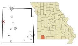
Location of Wheaton, Missouri
|
|
| Country | United States |
| State | Missouri |
| County | Barry |
| Township | Wheaton |
| Area | |
| • Total | 0.51 sq mi (1.32 km2) |
| • Land | 0.51 sq mi (1.32 km2) |
| • Water | 0.00 sq mi (0.00 km2) |
| Elevation | 1,371 ft (418 m) |
| Population
(2020)
|
|
| • Total | 672 |
| • Density | 1,322.83/sq mi (510.54/km2) |
| Time zone | UTC-6 (Central (CST)) |
| • Summer (DST) | UTC-5 (CDT) |
| ZIP code |
64874
|
| Area code(s) | 417 |
| FIPS code | 29-79126 |
| GNIS feature ID | 2397296 |
Wheaton is a small city in Barry County, Missouri, United States. It is located within Wheaton Township. In 2020, about 672 people lived there.
Contents
History of Wheaton
Wheaton has an interesting past, especially with its connection to railroads.
Railroad and Depot
The Missouri and North Arkansas Railroad used to serve the city. This railroad was important for moving goods and people. The old Wheaton Depot is a special building. It was added to the National Register of Historic Places in 2000. This means it is recognized as an important historical site.
Community Events
One popular event in Wheaton is the Wheaton Barbeque. It is a long-standing summer event held at Wheaton Park. It brings the community together for fun and food.
Geography of Wheaton
Wheaton is located in the western part of Barry County. It is very close to the line that separates Barry County from Newton County.
Location and Area
The city is situated on Route 86. This road is about one mile north of Missouri Route 76. According to the United States Census Bureau, Wheaton covers a total area of about 0.51 square miles (1.32 square kilometers). All of this area is land.
People of Wheaton
The population of Wheaton has changed over the years.
| Historical population | |||
|---|---|---|---|
| Census | Pop. | %± | |
| 1920 | 374 | — | |
| 1930 | 359 | −4.0% | |
| 1940 | 393 | 9.5% | |
| 1950 | 394 | 0.3% | |
| 1960 | 341 | −13.5% | |
| 1970 | 360 | 5.6% | |
| 1980 | 548 | 52.2% | |
| 1990 | 637 | 16.2% | |
| 2000 | 721 | 13.2% | |
| 2010 | 696 | −3.5% | |
| 2020 | 672 | −3.4% | |
| U.S. Decennial Census | |||
2010 Census Information
In 2010, there were 696 people living in Wheaton. These people lived in 274 households, and 175 of these were families. The city had about 1365 people per square mile.
Most of the people in Wheaton were White (89.8%). There were also smaller groups of African American, Native American, and Asian residents. About 7.5% of the population identified as Hispanic or Latino.
Households and Families
Many households (35.8%) had children under 18 living with them. About 45.6% of households were married couples living together. Some households (15.3%) had a female head with no husband. A small number (2.9%) had a male head with no wife. About 36.1% of households were not families.
Many people (32.8%) lived alone. About 15.7% of households had someone aged 65 or older living by themselves. The average household had 2.54 people, and the average family had 3.17 people.
Age and Gender
The average age in Wheaton in 2010 was 35.8 years.
- 29.5% of residents were under 18 years old.
- 8.1% were between 18 and 24 years old.
- 23.9% were between 25 and 44 years old.
- 24.7% were between 45 and 64 years old.
- 13.6% were 65 years old or older.
When it came to gender, 46.1% of the population was male, and 53.9% was female.
See also
 In Spanish: Wheaton (Misuri) para niños
 | John T. Biggers |
 | Thomas Blackshear |
 | Mark Bradford |
 | Beverly Buchanan |

