
Whetstone River facts for kids
Quick facts for kids Whetstone River |
|
|---|---|

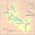
Map of the Minnesota River watershed with the Whetstone River highlighted (including the North and South forks)
|
|
| Country | United States |
| State | Minnesota |
| Physical characteristics | |
| Main source | confluence of its North and South forks northeast of Milbank, South Dakota |
| River mouth | Minnesota River Ortonville, Minnesota 45°17′50″N 96°27′00″W / 45.2972°N 96.4500°W |
| Length | 12.7 km (7.9 mi) |
| Basin features | |
| Tributaries |
|

The Whetstone River is a river that flows for about 12.7-mile-long (20.4 km). It is a tributary of the Minnesota River. This means it is a smaller river that flows into a larger one. The Whetstone River is mostly in northeastern South Dakota. A very small part of it also flows through western Minnesota in the United States.
The water from the Whetstone River eventually joins the Minnesota River. From there, it flows into the Mississippi River. This whole area, where water drains into a main river, is called a watershed. So, the Whetstone River is part of the huge Mississippi River watershed.
Contents
Where Does the Whetstone River Flow?
The Whetstone River starts when two smaller rivers meet. These are called the North Fork Whetstone River and the South Fork Whetstone River. They join together about 4 miles (6 km) northeast of Milbank, South Dakota.
From there, the Whetstone River generally flows eastward. It crosses a hilly area known as the Coteau des Prairies. This journey takes it through northern Grant County. It also flows past the town of Big Stone City.
The river then crosses the state line into Minnesota. It flows for about 0.25 mi (0.4 km) in Minnesota. Finally, it enters the Minnesota River near Ortonville, Minnesota. This meeting point is just downstream from where the Minnesota River leaves Big Stone Lake.
How Much Water Flows in the River?
Near Big Stone City, the Whetstone River carries a certain amount of water. On average each year, about 69 cubic feet of water flow past this point every second. This measurement helps scientists understand the river's size and how much water it moves.
The North and South Forks
Before the Whetstone River becomes one main river, it collects water from two important branches. These are the North Fork Whetstone River and the South Fork Whetstone River. Both of these forks also begin on the Coteau des Prairies.
The North Fork Whetstone River flows southeast. It starts in Roberts County. This fork also passes close to the town of Wilmot.
The South Fork Whetstone River flows westward. It is located in Grant County. This fork flows past the town of Milbank. These two forks are very important for feeding water into the main Whetstone River.
Images for kids
-
Map of the Minnesota River watershed with the Whetstone River highlighted (including the North and South forks)
