White Deer, Texas facts for kids
Quick facts for kids
White Deer, Texas
|
|
|---|---|

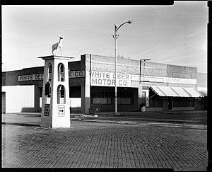
Downtown White Deer
|
|

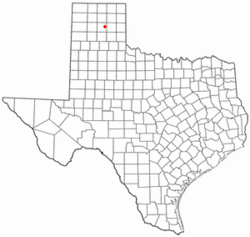
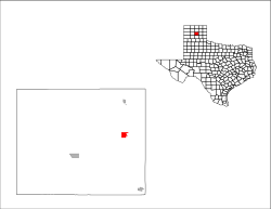
Location of White Deer, Texas
|
|
 |
|
| Country | United States |
| State | Texas |
| County | Carson |
| Area | |
| • Total | 1.74 sq mi (4.51 km2) |
| • Land | 1.74 sq mi (4.51 km2) |
| • Water | 0.00 sq mi (0.00 km2) |
| Elevation | 3,366 ft (1,026 m) |
| Population
(2020)
|
|
| • Total | 918 |
| • Density | 527.6/sq mi (203.5/km2) |
| Time zone | UTC-6 (Central (CST)) |
| • Summer (DST) | UTC-5 (CDT) |
| ZIP code |
79097
|
| Area code(s) | 806 |
| FIPS code | 48-78316 |
| GNIS feature ID | 2413477 |
White Deer is a small town located in Carson County, Texas, in the United States. In 2020, about 918 people lived there. It is considered part of the larger Amarillo area.
Contents
Where is White Deer Located?
White Deer is found along U.S. Highway 60. It is in the eastern part of Carson County. The town is about 13 miles northeast of Panhandle, which is the county seat. It is also about 40 miles northeast of the city of Amarillo.
According to the United States Census Bureau, White Deer covers an area of about 4.5 square kilometers (1.7 square miles). All of this area is land.
White Deer's Climate
White Deer has a semiarid climate. This means it is usually dry, but not a desert. On climate maps, this type of weather is called BSk.
A Look at White Deer's History
The area where White Deer is now was first settled around 1882. A company from the British called Francklyn Land and Cattle Company started a ranch there. This company later became the White Deer Land Company. They brought cattle to the area.
In 1887, George Tyng, who managed the ranch, built the main headquarters. Around the same time, a company called Purcell bought land for a railroad line. A train station was built in 1888. The place was first called "Paton," then "Whig." In 1899, it was named White Deer, after a nearby creek.
During the 1890s, British owners began selling land to settlers. People started small farms and ranches. In 1908, the community moved to its current spot near the railroad. A year later, Henry Czerner and Ben Urbanczyk helped Polish farmers from Central Texas settle on the northeast side of town. By 1910, about 50 people lived in White Deer.
Growth and Challenges
In 1919, oil and gas were found in Carson County. This discovery helped White Deer and the surrounding area grow. The community officially became a town in 1921. By the mid-1920s, the population had grown to 200 people.
At the peak of the "oil boom" in the late 1920s, nearly 3,000 people lived in White Deer. An oil boom is a time when a lot of oil is found, bringing many jobs and people to an area.
After this boom, the town faced some tough times. A big fire in 1931 caused a lot of damage. The Great Depression, a time of severe economic hardship in the 1930s, also affected the town. Tornadoes in 1945 and 1951 added to the challenges. These events caused the town's population to decrease.
By the late 1950s, White Deer became a place where grain and cattle from the area were shipped out. In 1980, the population was 1,210. It then went down to 1,125 in 1990 and 1,060 in 2000.
The White Deer Statue
In the center of the town's main intersection, there is a statue of a white deer. It stands on a concrete base. A historical marker, placed in 1965, is at the base of the statue. This marker tells about the town's interesting history.
White Deer's Population
| Historical population | |||
|---|---|---|---|
| Census | Pop. | %± | |
| 1930 | 1,010 | — | |
| 1940 | 733 | −27.4% | |
| 1950 | 629 | −14.2% | |
| 1960 | 1,057 | 68.0% | |
| 1970 | 1,092 | 3.3% | |
| 1980 | 1,210 | 10.8% | |
| 1990 | 1,125 | −7.0% | |
| 2000 | 1,060 | −5.8% | |
| 2010 | 1,000 | −5.7% | |
| 2020 | 918 | −8.2% | |
| U.S. Decennial Census | |||
What the 2020 Census Shows
The 2020 United States census counted 918 people living in White Deer. There were 318 households and 234 families in the town. A household means all the people living in one home.
| Race | Number | Percentage |
|---|---|---|
| White (NH) | 762 | 83.01% |
| Black or African American (NH) | 1 | 0.11% |
| Native American or Alaska Native (NH) | 2 | 0.22% |
| Asian (NH) | 2 | 0.22% |
| Mixed/Multi-Racial (NH) | 63 | 6.86% |
| Hispanic or Latino | 88 | 9.59% |
| Total | 918 |
Tornado Activity in White Deer
The White Deer area has had a bit more tornado activity than the average for Texas. It is 118% higher than the average for the entire U.S.
On June 8, 1995, a very strong F4 tornado hit about 11.7 miles from White Deer. An F4 tornado has maximum wind speeds between 207 and 260 miles per hour. This tornado injured seven people and caused a lot of damage, estimated between $5 million and $50 million.
Another F4 tornado occurred on June 27, 1992. This one was about 22 miles from the town center. It also injured seven people and caused between $5 million and $50 million in damages.
Education in White Deer
Public schools in White Deer are managed by the White Deer Independent School District. The district has around 400 students. These students attend two main schools.
One school is White Deer Elementary School, which teaches students from Pre-Kindergarten through 8th grade. The other school is White Deer High School, for students in grades 9 through 12. You can find more information on their website: White Deer ISD.
See also
 In Spanish: White Deer (Texas) para niños
 | Bayard Rustin |
 | Jeannette Carter |
 | Jeremiah A. Brown |

