
Whitefish Island facts for kids
Quick facts for kids
Whitefish Island
|
|
|---|---|
| Whitefish Island Indian Reserve | |

An aerial view of the St. Marys River; Whitefish Island is just to the left of the rapids.
|
|

Whitefish Island
Location in Ontario
|
|
| Country | |
| Province | |
| District | Algoma |
| First Nation | Batchewana Ojibways |
| Area | |
| • Land | 0.17 km2 (0.07 sq mi) |
| Population
(2011)
|
|
| • Total | 0 |
| • Density | 0/km2 (0/sq mi) |
| Time zone | UTC-5 (EST) |
| • Summer (DST) | UTC-4 (EDT) |
| Website | www.batchewana.ca |
| Official name: Whitefish Island National Historic Site of Canada | |
| Designated: | 1981 |
Whitefish Island is a small island located in the St. Marys River. You can find it just south of Sault Ste. Marie in Ontario, Canada. This island is a special place with a long history. It is now an Indian reserve and a National Historic Site.
Contents
A Long History of Whitefish Island
Whitefish Island has been important for thousands of years. For over 2,000 years, the Anishinaabek people of the Great Lakes region used it as a place to fish. They relied on the river's fish for food.
Treaty and Changes
In 1850, a special agreement called the Robinson Huron Treaty was made. This treaty was between the Anishinaabek people and the British Crown (the government of Great Britain). The treaty set aside Whitefish Island for Chief 'Joe Sayer' Nebenaigoching and his community. This meant the island was meant for their use.
Later, in 1895, parts of the island became part of the Sault Ste. Marie Canal. This canal helps ships travel between Lake Superior and the lower Great Lakes.
Becoming a National Historic Site
Between 1902 and 1913, the island was taken by the government for railway purposes. It then became a park managed by Parks Canada. Because of its long and important history, Whitefish Island was named a National Historic Site of Canada in 1981. This means it's a place recognized for its historical value.
The Land Claim and Return
In 1982, the Batchewana Indian Band, part of the Batchewana First Nation of Ojibways, filed a land claim. They wanted their island back. The island is about 22 acres (0.09 square kilometers) in size.
Negotiations went on for many years without success. Because of this, Chief Edward James Sayers Nebenaigoching, a hereditary chief, stayed on the island from 1989 until 1992. This action helped bring attention to the claim.
Finally, in 1992, the land claim was settled. The Batchewana First Nation received 3.5 million dollars. In 1997, Whitefish Island was officially returned to its status as an Indian reserve. This was a big step in recognizing the rights of the Batchewana First Nation.
Nature on Whitefish Island
Whitefish Island is not just important for its history. It's also home to many plants and animals. The island is surrounded by the St. Marys River and its rapids, which create a unique environment.
Plants of the Island
You can find various interesting plants on Whitefish Island. Some examples include:
- February daphne flowers, which are usually found in Europe and Asia. It's a mystery how they arrived here!
- Narrow-leaf blue-eyed grass flowers, which grow near the rapids.
- Nodding ladies'-tresses, a type of orchid.
- Small purple fringed orchid, another beautiful orchid species.
- Trout-lily flowers, which bloom in early spring.
- Wild leek, also appearing in early spring.
- Wild raisin, a shrub that produces fruit.
Animals of the Island
The river around Whitefish Island is a great place for fish. You might see Steelhead trout in the St. Marys Rapids. These fish were introduced to the area.
You can also find Beaver dams along the Whitefish Channel. Beavers are busy builders and create dams to make their homes.
Images for kids
-
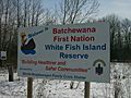
Welcome to White Fish Island
-
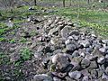
An ancient fishing weir
-
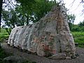
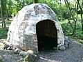
A birch bark longhouse
-
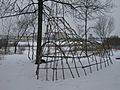
A longhouse in winter
-
A birch bark lodge
-
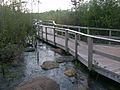
A boardwalk with 7 flood control gates open.
-
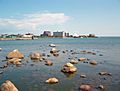
The Sault Ste. Marie waterfront, as seen from Whitefish Island
-
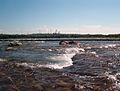
The St. Marys Rapids
-
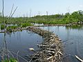
Beaver dams along Whitefish Channel
-
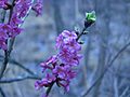
February daphne flowers
-
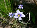
Narrow-leaf blue-eyed grass flowers near the St. Marys Rapids
-
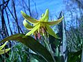
Trout-lily flower in early spring
-
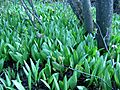
Wild leek in early spring
-
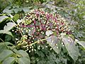
Wild raisin in fruit
-
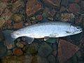
Steelhead trout caught in the St. Marys Rapids


_2.JPG)


_13.JPG)
.JPG)
_1.JPG)
_3.JPG)
_3.JPG)
_1.JPG)
_1.JPG)
_2.JPG)
