Whitiora Bridge facts for kids
Quick facts for kids Whitiora Bridge |
|
|---|---|

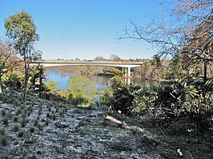
2012 view from riverside walkway
|
|
| Coordinates | 37°46′35.6″S 175°16′37.9″E / 37.776556°S 175.277194°E |
| Carries | Motor vehicles |
| Crosses | Waikato River |
| Owner | Hamilton City Council |
| Preceded by | Claudelands Bridge |
| Followed by | Fairfield Bridge |
| Characteristics | |
| Total length | 260 metres (850 ft) |
| Height | 28 metres (92 ft) |
| Number of spans | 45, 53, 64, 53, 45 m |
| History | |
| Constructed by | Rope Construction Ltd |
| Construction begin | 1975 |
| Construction end | 1978 |
| Statistics | |
| Daily traffic | 21,400 (2011), 25,200 (2015), 26,600 (2018) |
The Whitiora Bridge is a major bridge in Hamilton, New Zealand. It crosses the Waikato River. This bridge is made from prestressed concrete, which is a special type of concrete made extra strong. It uses a design called a box girder bridge, which means it has hollow, box-shaped sections.
The bridge officially opened on February 11, 1978. It was a big event, part of the city's Centennial celebrations. Important people like Dame Te Atairangikaahu (a Māori leader), Venn Young (a government representative), and Ross Jansen (from the city) helped open it. The bridge cost about $2.35 million to build, or $3.4 million if you include the roads leading up to it.
Contents
Building the Whitiora Bridge
Why was the bridge needed?
Before the Whitiora Bridge, people in Hamilton had to use other bridges to cross the Waikato River. In 1969, a study about transportation in Hamilton suggested building this new bridge. It was designed to help traffic move better across the city.
Who designed and built it?
The bridge was designed by a company called Murray North Partners. They also designed other important structures in New Zealand. The actual building work was done by Rope Construction Ltd. They are known for building large projects like the Rakaia Bridge.
How was the bridge built?
The Whitiora Bridge is built on Taupo pumice alluvium. This is a type of soil made from volcanic ash and river deposits. The bridge has four large, octagonal (eight-sided) piers. These piers are like strong legs that support the bridge. They go deep into the ground, about 30 meters (98 feet) below the river.
The bridge is 260 meters (853 feet) long. This makes it much longer than the nearby Claudelands Bridge (133 meters) and Fairfield Bridge (139 meters). The way the bridge was angled, or "skewed," helped avoid damaging too many trees. It also lined up well with a new extension of Boundary Road.
Keeping the bridge safe
The Whitiora Bridge has special features to protect it during an earthquake. It uses "sliding hinge joints" in the parts of the bridge closest to land. These joints allow the bridge to move a little during shaking. It also has "hydraulic shock transmission" at its expansion joints. This helps keep the different sections of the bridge together during an earthquake.
Traffic and Naming
How many vehicles use the bridge?
The Whitiora Bridge is a very busy route. In 2011, about 21,400 vehicles crossed it every day. By 2018, this number grew to about 26,600 vehicles daily. The bridge carries Boundary Road over the river and River Road.
Changes for cyclists
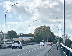
When the bridge was first designed in 1972, it was planned to have up to four traffic lanes. In 2006, the bridge was changed. It went from having two traffic lanes, separate cycle tracks, and a footpath to three traffic lanes and just one footpath.
This change meant less space for cyclists. A group called Cycle Action Waikato complained about this in 2014. Around 200 cyclists use the bridge each day. The city council has thought about adding a special "clip-on" lane just for bikes. They have even set aside $1 million for this project in 2028.
What does "Whitiora" mean?
During its design and construction, the bridge was often called the Boundary Road Bridge. The name "Whitiora" was chosen from a public suggestion. It comes from two Māori words:
- Whiti: This is the call of the pipiwharauroa, a type of bird.
- Ora: This word means life or health.
So, the name "Whitiora" connects the bridge to nature and well-being.
Nearby History
Just south of the Whitiora Bridge, beside River Road, is a place called Miropiko pā. A "pā" is a traditional Māori fortified village. Miropiko pā is one of the best-preserved pā sites in Hamilton.
 | Mary Eliza Mahoney |
 | Susie King Taylor |
 | Ida Gray |
 | Eliza Ann Grier |


