
Whoap facts for kids
Quick facts for kids Whoap |
|
|---|---|

Whoap (left) from the valley
of the River Calder |
|
| Highest point | |
| Elevation | 511 m (1,677 ft) |
| Parent peak | Lank Rigg |
| Geography | |

Whoap
Location in Lake District
|
|
Whoap is a hill found near the western edge of the famous Lake District in England. It stands tall at 511 meters (about 1,677 feet) above sea level. Whoap is part of a group of hills called the Lank Rigg group. It is separated from the main Lank Rigg hill by a low area of land, like a dip, which locals call the Whoap Step.
Whoap is not one of the "Wainwrights." These are 214 special hills in the Lake District described by a famous author, Alfred Wainwright. However, Whoap does get a small mention in his books about nearby hills like Lank Rigg and Crag Fell.
Contents
What Does Whoap Look Like?
Whoap is shaped a bit like a tongue. It lies between Lank Rigg to its south and Crag Fell to its north. The side of Whoap that faces south is much steeper than its other sides. You might see a small area of loose rocks, called scree, on this steep part. But there are no big rocky cliffs or outcrops here.
How to Climb Whoap
Climbing Whoap is easiest if you start from the Coldfell road. This road makes a sharp turn near the bottom of two other places, Blakeley Raise and Burn Edge. From there, a path goes down into the Calder valley.
You will cross a small stream called Comb Beck. The path then continues along the valley until you reach a place where you can cross the River Calder itself.
Choosing Your Path to the Top
Once you cross the Calder River, you have two ways to go:
- Option 1: Turn left and climb straight up Whoap. This way is more direct.
- Option 2: Continue along the valley to the dip (the "col") that separates Whoap from Lank Rigg. Then, turn left for the final climb to the top. This second path is not as hard. However, the ground can get quite muddy and wet after it rains.
Views from the Summit
The very top of Whoap is marked by a small boulder. From here, you can enjoy some great views! You can see other hills like Grike and Crag Fell. You can also look down at the area between Whoap and Crag Fell, which is known as Black Potts.
Images for kids
-
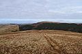
View from Whoap, looking West
-
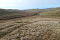
The Calder Valley


