Blakeley Raise facts for kids
Quick facts for kids Blakeley Raise |
|
|---|---|

Blakeley Raise, from Dent
|
|
| Highest point | |
| Elevation | 389 m (1,276 ft) |
| Parent peak | Crag Fell |
| Geography | |
| Topo map | OS Landranger 89, 90, Explorer OL4 |
Blakeley Raise is a lovely hill, known as a "fell," located in the beautiful Lake District in England. It stands 389 meters (about 1,276 feet) tall. Even though it's not one of the famous Wainwrights like its neighbors Grike or Crag Fell, Blakeley Raise is still a great place to explore.
Climbing Blakeley Raise offers amazing views. You can see far across West Cumbria, into Southern Scotland, and even to the Isle of Man. From its top, you might spot towns like Whitehaven and Cleator Moor, and a large industrial site called Sellafield.
What Blakeley Raise Looks Like
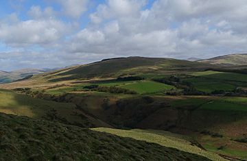
Blakeley Raise is a gentle, rounded hill. It has a soft, dome-like shape. To the northeast, it connects to Heckbarley, which is a smaller part of the nearby Grike fell.
Special Features of the Hill
The lower western parts of Blakeley Raise have a wet area called Blakeley Moss. This is a special type of wetland. You can also find the Kinniside Stone Circle here. This is an ancient circle made of stones.
Forests and Open Land
The northern slopes of Blakeley Raise are covered with thick forests. Some of these trees were cut down in the mid-1990s. But new trees were planted soon after. More trees have recently been harvested near the top of the hill. The rest of Blakeley Raise is open grassland. You might see horses and sheep grazing there.
 | Georgia Louise Harris Brown |
 | Julian Abele |
 | Norma Merrick Sklarek |
 | William Sidney Pittman |


