Wilbraham (CDP), Massachusetts facts for kids
Quick facts for kids
Wilbraham, Massachusetts
|
|
|---|---|

Main Street
|
|

Location in Hampden County in Massachusetts
|
|
| Country | United States |
| State | Massachusetts |
| County | Hampden |
| Town | Wilbraham |
| Area | |
| • Total | 5.65 sq mi (14.65 km2) |
| • Land | 5.59 sq mi (14.48 km2) |
| • Water | 0.06 sq mi (0.16 km2) |
| Elevation | 279 ft (85 m) |
| Population
(2020)
|
|
| • Total | 4,003 |
| • Density | 715.84/sq mi (276.39/km2) |
| Time zone | UTC-5 (Eastern (EST)) |
| • Summer (DST) | UTC-4 (EDT) |
| ZIP code |
01095
|
| Area code(s) | 413 |
| FIPS code | 25-79705 |
| GNIS feature ID | 0609368 |
Wilbraham is a special area in the town of Wilbraham in Hampden County, Massachusetts, United States. It is called a "census-designated place" (CDP) because the U.S. Census Bureau counts its population separately. In 2020, about 4,003 people lived here. The whole town of Wilbraham had about 14,868 people in 2010. This area is also part of the larger Springfield Metropolitan Statistical Area, which means it's connected to the economy and community of the nearby city of Springfield.
Contents
Exploring Wilbraham's Location
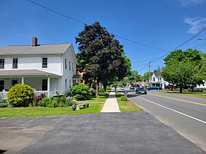
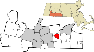
The Wilbraham CDP is located in the middle and northern parts of the town. This includes the main town center, where you can find Main Street, Mountain Road, and Springfield Street.
Borders and Nearby Cities
The CDP has clear boundaries. To the north, it is bordered by U.S. Route 20. On the east, you'll find Mountain Road and Ridge Road, which are near the top of the small Wilbraham Mountains. To the south, its borders include Monson Road, Hunting Lane, Ripley Street, and Springfield Street. On the west side, it's bordered by Stony Hill Road, Glen Drive, and Brainard Road. Wilbraham is about 9 miles (14 km) east of downtown Springfield.
Size and Water Features
The United States Census Bureau measures the size of places. The Wilbraham CDP covers a total area of about 14.7 square kilometers (5.7 square miles). Most of this area, about 14.5 square kilometers (5.6 square miles), is land. A small part, about 0.2 square kilometers (0.08 square miles), is water.
Who Lives in Wilbraham?
| Historical population | |||
|---|---|---|---|
| Census | Pop. | %± | |
| 2020 | 4,003 | — | |
| U.S. Decennial Census | |||
In 2000, there were 3,544 people living in the Wilbraham CDP. These people lived in 1,247 homes, and 981 of these were families. The population density was about 242 people per square kilometer (628 people per square mile).
Community and Families
Many homes in Wilbraham are families. About 35% of homes had children under 18 living there. Most families, about 67%, were married couples. About 18% of all homes were single people living alone. Some of these were people aged 65 or older. On average, there were about 2.66 people in each home and 3.02 people in each family.
Age and Income
The people in Wilbraham are of different ages. About 24.8% were under 18 years old. About 22% were 65 years or older. The average age was 44 years.
In 2000, the average income for a household in Wilbraham was about $66,814 per year. For families, the average income was about $71,825 per year.
See also
 In Spanish: Wilbraham (condado de Hampden) para niños
 | Jackie Robinson |
 | Jack Johnson |
 | Althea Gibson |
 | Arthur Ashe |
 | Muhammad Ali |

