
Wiley, Colorado facts for kids
Quick facts for kids
Wiley, Colorado
|
|
|---|---|

Wiley from the east (2013)
|
|

Location with Prowers County and Colorado
|
|
| Country | United States |
| State | Colorado |
| County | Prowers |
| Incorporated | January 28, 1909 |
| Area | |
| • Total | 0.31 sq mi (0.81 km2) |
| • Land | 0.31 sq mi (0.81 km2) |
| • Water | 0 sq mi (0 km2) |
| Elevation | 3,740 ft (1,140 m) |
| Population
(2020)
|
|
| • Total | 437 |
| • Density | 1,410/sq mi (540/km2) |
| Time zone | UTC−7 (MST) |
| • Summer (DST) | UTC−6 (MDT) |
| ZIP Code |
81092
|
| Area code | 719 |
| FIPS code | 08-85045 |
| GNIS ID | 2413488 |
Wiley is a small town in Prowers County, Colorado, United States. In 2020, about 437 people lived there. It is known as a "statutory town," which means it follows certain state laws for towns.
Contents
About Wiley
Wiley got its name from W. M. Wiley, who was one of the first people to settle there. A post office has been open in Wiley since 1907. The town was officially made a municipality on January 28, 1909.
Where is Wiley?
Wiley is a very small town. It covers about 0.3 square miles (0.8 square kilometers) of land. It is located in the eastern part of Colorado.
People in Wiley
Wiley's population has changed over the years. Here's how many people have lived there during different census counts:
| Historical population | |||
|---|---|---|---|
| Census | Pop. | %± | |
| 1910 | 197 | — | |
| 1920 | 565 | 186.8% | |
| 1930 | 589 | 4.2% | |
| 1940 | 413 | −29.9% | |
| 1950 | 417 | 1.0% | |
| 1960 | 383 | −8.2% | |
| 1970 | 357 | −6.8% | |
| 1980 | 425 | 19.0% | |
| 1990 | 406 | −4.5% | |
| 2000 | 483 | 19.0% | |
| 2010 | 405 | −16.1% | |
| 2020 | 437 | 7.9% | |
| U.S. Decennial Census | |||
Families and Homes
In 2010, there were 405 people living in 162 homes in Wiley. About 112 of these were families. The town had about 1,384 people per square mile.
Many homes had children under 18 living there. More than half of the homes were married couples living together. Some homes had a single female parent. About 28% of homes were individuals living alone.
Age Groups
The people in Wiley are spread across different age groups. In 2010:
- About 31% of the population was under 18 years old.
- About 34% of the population was between 25 and 44 years old.
- About 9.5% of the population was 65 years or older.
The average age in Wiley was 32 years old.
Getting Around Wiley
Roads
Wiley is very close to U.S. Highway 287. This major road is just 0.2 miles east of the town.
Trains
In the past, Wiley had train service. The Acheson, Topeka and Santa Fe railway used to have a line called the Arkansas Valley subdivision that served the town. This train service is no longer active.
Images for kids
-
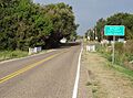
Wiley from the east (2013)
-
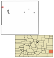
Location with Prowers County and Colorado
See also
 In Spanish: Wiley (Colorado) para niños
