
Wilhelmina Bay facts for kids

Wilhelmina Bay is a large bay about 24 kilometers (15 miles) wide. It is located on the west coast of Graham Land, which is part of the Antarctic Peninsula. This bay stretches between the Reclus Peninsula in the northeast and Cape Anna in the southwest.
The bay was first explored by the Belgian Antarctic Expedition between 1897 and 1899. This journey was led by a person named Adrien de Gerlache. Wilhelmina Bay gets its name from Wilhelmina, who was the Queen of the Netherlands from 1890 to 1948.
Wilhelmina Bay is a very popular spot for tourist ships visiting Antarctica. People love to see its amazing scenery and the many humpback whales that live there. The bay is surrounded by tall, steep cliffs covered in snow and glaciers.
Contents
Exploring Wilhelmina Bay's Geography
Coastline Features
The southernmost part of Wilhelmina Bay has a smaller area called Piccard Cove. This cove is bordered on its eastern side by Sophie Cliff, a granite cliff that marks the end of Balis Ridge. On the western side, O'Neal Point separates Piccard Cove from Beaupré Cove.
Beaupré Cove is about 2 kilometers (1 nautical mile) wide. It is bordered by O'Neal Point and Jones Point. The Nadjakov Glacier feeds into the head of this cove. Hugershoff Cove is found at the southwestern end of Wilhelmina Bay. It is less than 2 kilometers (1 nautical mile) south of Louise Island and Emma Island, and about 4 kilometers (2 nautical miles) northwest of Beaupré Cove.
Islands in the Bay

Wilhelmina Bay is big enough to hold several islands. The largest of these is Nansen Island, also known as Isla Nansen Sur. About 6.4 kilometers (4 miles) to the west is Emma Island, which is about 2.8 kilometers (1.5 nautical miles) long. Emma Island is mostly covered in ice, but jagged peaks stick out.
Louise Island is also covered in ice and is about 1 kilometer (0.6 miles) long. It sits about 1.6 kilometers (1 mile) west of Emma Island. Louise Island is also 1.6 kilometers (1 mile) east of Cape Anna and Anna Cove, which are on the southwest side of the entrance to Wilhelmina Bay.
How Places in the Bay Got Their Names
Most of the features in Wilhelmina Bay were mapped by the Belgian Antarctic Expedition from 1897 to 1899, led by Gerlache. Gerlache gave names to many places, often honoring his friends, people who supported the expedition, or members of his team.
For example, Nansen Island was named after a famous Arctic explorer named Fridtjof Nansen. Emma Island was named after his mother, and Louise Island was named after his sister.
Some places mapped by Gerlache were not named at that time. The United Kingdom Antarctic Place-Names Committee (UK-APC) named these features in 1960. Piccard Cove was named for Auguste Piccard, a Swiss physicist. Beaupré Cove was named for Charles-François Beautemps-Beaupré, a French expert in mapping water bodies. Jones Point was named for an engineer named Bennett M. Jones. Hugershoff Cove was named for Carl R. Hugershoff, a German expert in measuring the Earth.
O'Neal Point was named for James D. O'Neal, an American mapmaker.
Images for kids
-
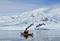
A kayaker watches whales in Wilhelmina Bay
-
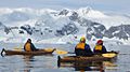
Kayakers enjoying Wilhelmina Bay
-
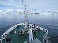
The expedition ship Akademik Ioffe sailing into Wilhelmina Bay in January 2014
-
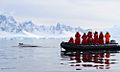
A tourist boat called a Zodiac gets a close look at a humpback whale in Wilhelmina Bay


See also
 In Spanish: Bahía Wilhelmina para niños
- Geology of Gerlache Strait
- Plata Passage
