Willamette Lowland basin-fill aquifer facts for kids
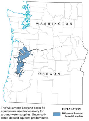
The Willamette Lowland basin-fill aquifer is a huge underground area that holds water. It's about 31,000 square kilometers (12,000 square miles) in size! This aquifer is located under parts of Oregon and Washington (state). It sits between the Oregon Coast Range and the Cascade Range mountains.
This aquifer is named after the Willamette River, which flows nearby. The word "Willamette" comes from the Clackamas Chinook language. The "mette" part of the word meant "water" or "river" to them.
About 70% of Oregon's people live in the Willamette Valley. This aquifer provides a lot of their water. It's used for farming, homes, and factories. In 2005, people used about 1.6 billion liters (420 million gallons) of water from the aquifer each day. Most of this water (58%) went to water crops. About 24% was for public water supplies, and 18% was for industrial use.
Generally, the aquifer gets enough water back from rain and snow. This helps keep its levels stable over time. However, some parts of the aquifer have shown long-term drops in water levels. This includes areas where the Columbia River basalt rock is found. During the dry summer months (June to September), using a lot of water from the aquifer causes the underground water level to drop significantly. It can change by more than 60 feet!
In Oregon, all water belongs to the public. The Oregon Water Resources Department and the Oregon Water Resources Commission help manage and protect this water. Local governments can also give permits for using land over the aquifer. This includes permits for new homes in rural areas.
Contents
What is an Aquifer?
An aquifer is like a giant sponge underground. It's a layer of rock or soil that can hold and let water flow through it. People drill wells into aquifers to get water for drinking, farming, and other uses.
How the Aquifer is Built: Underground Layers
The Willamette Lowland basin-fill aquifer is made of many different types of rock and soil. Scientists group these into six main categories. They are listed from the deepest layer to the one closest to the surface.
The Deepest Layer: Basement Unit
The very bottom layer is called the basement confining unit. It's made of old marine rocks and volcanic rocks. These rocks don't let much water through. They have low permeability (how easily water flows) and low porosity (how much space there is to hold water). But they can still provide a small amount of water.
The Basalt Layer: Columbia River Unit
Above the basement unit is the Columbia River basalt unit. This layer is made of old lava flows. Water is stored in the spaces between these lava flows. Over time, weathering has created tiny holes in the rock, which hold water. Water can flow sideways through this layer. However, it's very hard for water to move up or down through it.
Main Water Holders: Sedimentary Units
- Lower Sedimentary Unit: This layer often sits right on top of the basement unit, or above the basalt layer. It makes up most of the aquifer's "fill." This layer formed from eroded rocks that filled the basin. Some parts, like sand and gravel beds, can hold and give up a lot of water.
- Middle Sedimentary Unit: This layer is usually on top of the lower sedimentary unit. It's often thinner. It's mostly made of sands and gravels from a time called the Pleistocene (the Ice Age). Both the lower and middle sedimentary units have lots of space to hold water (high porosity) and let water flow easily (high permeability). This means they can provide a lot of water. Farmers often use water from these layers to irrigate their crops.
The Top Layer: Willamette Silt Unit
The very top layer is the Willamette silt unit. It's made of very fine dirt called silt. This silt covers most of the lowland area. In some places, it has been washed away by water. This silt layer can hold a lot of water because it has high porosity. However, water doesn't flow through it easily (low permeability). So, it's hard to get large amounts of water out quickly. This layer was important for early settlers to get water for their homes. Where the silt layer exists, it acts like a cap. It keeps the water in the layers below from moving up easily. This makes the aquifer behave like a "confined aquifer" in those areas.
How the Aquifer Gets Refilled: Recharge
The Willamette Valley gets a lot of rain. This helps refill the aquifer with large amounts of water. In the low areas, it can rain more than 1,400 millimeters (55 inches) per year. In the mountains, it can rain over 2,500 millimeters (100 inches) per year!
When the middle, lower sedimentary, and Columbia River basalt units are exposed at the surface, rainwater can seep directly into them. However, the Willamette silt unit on top makes it harder for water to reach the layers below it. This is because water moves very slowly through the silt.
Studies show that the mountainous regions get a lot of recharge, sometimes over 100 centimeters (40 inches) per year. Most of this water likely flows into streams, so it doesn't always reach the deeper parts of the aquifer in the lowlands.
Because the Columbia River basalt unit doesn't let water move up or down easily, it's hard for its deeper parts to get refilled. When people pump water from the deep Columbia River unit, it can affect water levels far away, even six miles or more! This causes long-term drops in water levels in this unit, which aren't usually seen in other parts of the aquifer.


