
Williams Peak (Custer County, Idaho) facts for kids
Quick facts for kids Williams Peak |
|
|---|---|

Williams Peak
|
|
| Highest point | |
| Elevation | 10,635 ft (3,242 m) |
| Prominence | 837 ft (255 m) |
| Parent peak | Thompson Peak |
| Geography | |

Williams Peak
Location in Idaho
|
|
| Parent range | Sawtooth Range |
| Topo map | USGS Stanley Lake |
| Climbing | |
| First ascent | 1934 |
| Easiest route | Scramble - Class 3 |
Williams Peak is a tall mountain in the Sawtooth Mountains of Idaho, U.S. It stands at about 10,636 feet (3,242 meters) high. This makes it the 6th highest peak in the Sawtooth Range. The mountain is part of the Sawtooth Wilderness, which is inside the Sawtooth National Recreation Area.
Williams Peak is located about 0.75 miles (1.2 kilometers) northwest of Thompson Peak. Thompson Peak is the very highest mountain in the Sawtooth Range. The town of Stanley, Idaho is about 5.5 miles (8.9 kilometers) northeast of Williams Peak. You can see great views of the peak from the scenic Idaho State Highway 75. You can also see it from hiking trails around Redfish Lake and other parts of the Sawtooth and White Cloud Mountains.
Contents
Mountain History
Williams Peak is named after a pioneer named Dave Williams. He was one of the first people to climb the mountain in 1934. He climbed it with Robert and Miriam Underhill. Dave Williams also owned the land where the Idaho Rocky Mountain Ranch is today. This ranch has a clear view of Williams Peak.
Exploring the Routes
There are many ways to climb Williams Peak, suitable for different skill levels. The southern parts of the mountain have exciting routes for scrambling. Scrambling is like climbing, but you use both your hands and feet. The steep North Face of the mountain offers a classic alpine climb. This means it's a more serious climb, going up over 1,100 feet (335 meters).
June/North Couloir Route
This route is a steep, narrow gully that goes up the northeast side of the mountain. It leads to a notch just below the very top. It's fairly easy to get to from the Alpine Way Trail near Marshall Lake. This route often has ice, rock, and snow. In winter, a large snow overhang (called a cornice) can block the top part. The first people to climb this route were Kirk Bachman and B. Franklin in 1986.
When climbing this route, you might need to use ropes because of the changing snow and ice conditions. The path is usually clear. Once you reach the top of the gully, you follow the ridge (a narrow line of high ground) to the west and then south to the summit. It's only about 400 feet (122 meters) from the top of the gully to the very top of the mountain. The easiest way to get back down is to use the routes on the south side of the mountain.
Southeast Slopes Route
This is likely the easiest and fastest way to climb Williams Peak. It's easy to reach from the Alpine Way Trail. In winter, this route is great for climbing on snow and skiing down the mountain.
East Ridge Route
This route is more challenging. It involves climbing up and down along the prominent ridge on the southeast side, above the Southeast Slopes route. There are parts where you are very high up with steep drops around you. You also have to cross steep, loose gullies (small valleys). Mountain goats have been seen on this route!
Southwest Couloir Route
You can easily get to this route from the saddle (a low point between two peaks) connecting Thompson Peak and Williams Peak. This means you could climb both mountains together. You can also reach it from the Lake 8865 area.
Images for kids
-
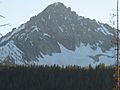
Williams Peak from near Stanley Ranger Station
-
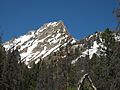
Williams Peak from Alpine Way Trail
-
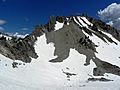
Williams Peak


