
Thompson Peak (Idaho) facts for kids
Quick facts for kids Thompson Peak |
|
|---|---|

Thompson Peak from near Stanley
|
|
| Highest point | |
| Elevation | 10,751 ft (3,277 m) NAVD 88 |
| Prominence | 2,431 ft (741 m) |
| Geography | |

Thompson Peak
Location in Idaho
|
|
| Parent range | Sawtooth Range |
| Topo map | USGS Stanley Lake |
| Climbing | |
| Easiest route | Hike, Scramble, class 3 |
Thompson Peak is the highest mountain in the Sawtooth Range in Idaho. It stands tall at 10,751 feet (about 3,277 meters) above sea level. This impressive peak is mostly located in Custer County. A smaller part of the mountain reaches into Boise County.
Thompson Peak is also part of the Sawtooth Wilderness. This is a protected area within the Sawtooth National Recreation Area, which is managed by the Sawtooth National Forest. The small town of Stanley, Idaho is only about 6 miles (10 km) northeast of Thompson Peak.
Contents
Exploring Thompson Peak's Location
Thompson Peak is surrounded by beautiful natural spots. Nearby are Redfish Lake and Little Redfish Lake. These lakes offer visitor services and are popular places to explore.
Right to the north of Thompson Peak is its neighbor, Williams Peak. A bit to the south-southwest, about 0.24 miles (0.39 km) away, you'll find a smaller peak called Mickey's Spire.
How to Reach Thompson Peak's Summit
There are a few ways to climb to the very top of Thompson Peak. Some routes are more challenging and require special climbing skills. The easiest way to reach the summit involves a mix of hiking and scrambling.
The Easiest Climbing Route
The most common and easiest way to get to Thompson Peak starts from the Redfish Lake trailhead.
- First, you take the Fishhook Creek Trail.
- Then, you switch to the Alpine Way Trail.
- Follow the Alpine Way Trail until you reach the base of Williams Peak.
- From there, you'll go off the main trail to an unnamed lake located northeast of Thompson Peak.
- Next, you head up to the saddle, which is the low point between Thompson Peak and Williams Peak.
- Finally, you begin a "class 3 scramble" on the west-southwest side of Thompson Peak. A class 3 scramble means you'll need to use your hands for balance and support, but it's not quite rock climbing. This scramble starts from the saddle between Thompson Peak and Mickey's Spire.
Other Climbing Paths
For more experienced climbers, there are other routes to the top:
- South Couloir: This route is rated class 3. The "YDS" stands for Yosemite Decimal System, which is a way to rate how hard a climb is. A 3 means it's a difficult scramble.
- Southwest Couloir: This route is rated 5.2. This rating means it's a technical rock climb that requires ropes and gear.
- Northeast Face: This is a more challenging climb, rated 5.8.
- West Crack: Another technical climbing route, rated 5.2.
Images for kids
-
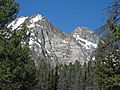
Thompson Peak from Alpine Way Trail
-
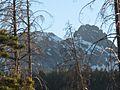
Thompson Peak from near Stanley Ranger Station
-
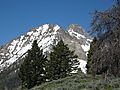
Thompson Peak as seen from Alpine Way Trail
-
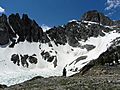
Thompson Peak from cirque below
.jpg)


