
Williams River (Oregon) facts for kids
Quick facts for kids Williams River |
|
|---|---|

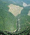
Clearcuts along the Williams River
|
|

Location of the mouth of the Williams River in Oregon
|
|
| Country | United States |
| State | Oregon |
| County | Douglas and Coos |
| Physical characteristics | |
| Main source | Confluence of Lost Creek and Little Cow Creek western Douglas County, Southern Oregon Coast Range 43°11′42″N 123°37′11″W / 43.19500°N 123.61972°W |
| River mouth | South Fork Coos River eastern Coos County, Southern Oregon Coast Range 476 ft (145 m) 43°19′06″N 123°48′33″W / 43.31833°N 123.80917°W |
| Length | 21 mi (34 km) |
The Williams River is a stream in the U.S. state of Oregon. It flows for about 21 miles (34 km) before joining the South Fork Coos River. This river starts where two smaller streams, Lost Creek and Little Cow Creek, meet.
The Williams River begins in western Douglas County. It then flows generally northwest through the Southern Oregon Coast Range. In eastern Coos County, it combines with Tioga Creek. This meeting forms the South Fork Coos River.
Contents
The River's Journey
The Williams River starts east of Bear Mountain. It flows northwest through thick forests. These forests are south of Yew Ridge in western Douglas County. This area is west of the city of Roseburg.
As the river continues, it passes Threemile Ridge. Several smaller streams join it along the way. These include Wilson Creek, Fivemile Creek, and Panther Creek. Bear Gulch also adds its water to the Williams River.
Entering Coos County
Around 14 miles (23 km) from its start, the Williams River crosses into Coos County. Soon after, Gooseberry Gulch joins the river. The river then turns northwest.
It briefly re-enters Douglas County before flowing back into Coos County. Along this path, Cabin Creek and Cedar Creek flow into the Williams River. Finally, Skip Creek and Bottom Creek also join the river.
Where It Ends
The Williams River then merges with Tioga Creek. Together, they form the South Fork Coos River. This marks the end of the Williams River's journey.
Animals in the River
The Williams River is home to different kinds of fish. You can find resident trout living here. Salmon and steelhead also use the river.
It can be hard to get to the river. Most of the land around it is privately owned. Sometimes, roads are blocked by gates. Fishing for salmon and steelhead is not allowed in this stream. Other types of fishing are generally not very good here.
Images for kids
-
Clearcuts along the Williams River
