Williamsburg, Florida facts for kids
Quick facts for kids
Williamsburg, Florida
|
|
|---|---|

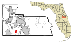
Location in Orange County and the state of Florida
|
|

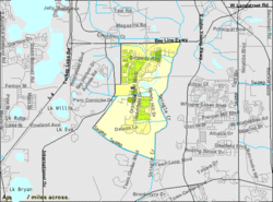
U.S. Census Bureau map showing CDP boundaries
|
|
| Country | |
| State | |
| County | Orange |
| Area | |
| • Total | 3.65 sq mi (9.45 km2) |
| • Land | 3.55 sq mi (9.20 km2) |
| • Water | 0.10 sq mi (0.25 km2) |
| Elevation | 89 ft (27 m) |
| Population
(2020)
|
|
| • Total | 7,908 |
| • Density | 2,226.98/sq mi (859.73/km2) |
| Time zone | UTC-5 (Eastern (EST)) |
| • Summer (DST) | UTC-4 (EDT) |
| FIPS code | 12-77735 |
| GNIS feature ID | 1867237 |
Williamsburg is a special kind of community in Orange County, Florida, United States. It's called a census-designated place (CDP). This means it's an area that looks like a town but isn't officially governed as one.
In 2010, about 7,646 people lived here. By 2020, the population grew to 7,908. Williamsburg is part of the larger Orlando and Kissimmee area, which is a big group of cities and towns.
Contents
Where is Williamsburg Located?
Williamsburg is found at coordinates 28°24′35″N 81°26′45″W / 28.40972°N 81.44583°W. This helps pinpoint its exact spot on a map.
How Big is Williamsburg?
According to the United States Census Bureau, Williamsburg covers a total area of about 9.7 square kilometers (3.8 square miles). Most of this area, 9.5 square kilometers (3.7 square miles), is land. A small part, 0.2 square kilometers (0.1 square miles), is water.
What are Williamsburg's Borders?
Williamsburg is a large neighborhood with clear boundaries. To the north, you'll find the Beachline Expressway. The Central Florida GreeneWay is to the south.
On the east side, there's Shingle Creek. To the west, you'll find International Drive. The main crossroad in the community is where Orangewood Boulevard and Central Florida Parkway meet.
How Traffic is Managed in Williamsburg
In the early 2000s, the people who manage Williamsburg's neighborhoods worked with local leaders. They wanted to make sure that traffic from the nearby Orange County Convention Center didn't drive right through Williamsburg.
They found a solution for the interchange between Orangewood Boulevard and the Beachline. This solution helped direct most of the southbound traffic onto the Beachline. Only one lane continued under the expressway to connect with Orangewood Boulevard. This helped keep local roads less crowded.
Who Lives in Williamsburg?
Williamsburg is home to many different people. Here's a look at the population numbers over the years:
| Historical population | |||
|---|---|---|---|
| Census | Pop. | %± | |
| 2020 | 7,908 | — | |
| U.S. Decennial Census | |||
Population Details from 2000
In the year 2000, there were 6,736 people living in Williamsburg. There were 3,262 households, which are groups of people living together in one home. Out of these, 2,035 were families.
The population density was about 706.7 people per square kilometer (1,830.4 per square mile). There were also 3,492 housing units, like houses or apartments.
Diversity in Williamsburg
The community of Williamsburg is made up of people from many different backgrounds. In 2000, most residents were White. There were also people who identified as African American, Native American, Asian, and Pacific Islander. Some residents were from other races or from two or more races. About 9.47% of the population identified as Hispanic or Latino.
Households and Families
Out of all the households in 2000, about 13.1% had children under 18 living there. More than half, 52.2%, were married couples living together. About 7.5% had a female head of household with no husband present.
Many households, 37.6%, were not families. About 28.6% of all households were individuals living alone. And 15.5% had someone aged 65 or older living by themselves. On average, there were 2.06 people per household and 2.49 people per family.
Age and Income in Williamsburg
The population in Williamsburg has a mix of ages. In 2000, 10.7% were under 18 years old. About 4.4% were between 18 and 24. A larger group, 27.7%, was between 25 and 44. Those aged 45 to 64 made up 24.0%. The largest group, 33.3%, was 65 years or older. The average age was 51 years.
The median income for a household was $46,460. For families, the median income was $51,791. The average income per person was $26,096. A small number of families (2.0%) and individuals (4.0%) lived below the poverty line. This included 2.9% of those under 18 and 3.9% of those 65 or older.
See also
 In Spanish: Williamsburg (Florida) para niños
 | Victor J. Glover |
 | Yvonne Cagle |
 | Jeanette Epps |
 | Bernard A. Harris Jr. |

