Wilson, Pennsylvania facts for kids
Quick facts for kids
Borough of Wilson
Wilson
|
||
|---|---|---|
|
Borough
|
||
|
||

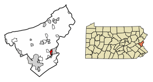
Location of Wilson in Northampton County, Pennsylvania (left) and of Northampton County in Pennsylvania (right)
|
||
| Country | ||
| State | ||
| County | Northampton | |
| Formed as a township | Feb. 10, 1913 | |
| Incorporated as a borough | July 12, 1920 | |
| Named for | Woodrow Wilson | |
| Area | ||
| • Borough | 1.16 sq mi (3.00 km2) | |
| • Land | 1.16 sq mi (2.99 km2) | |
| • Water | 0.01 sq mi (0.01 km2) | |
| Elevation | 394 ft (120 m) | |
| Population
(2020)
|
||
| • Borough | 8,259 | |
| • Density | 7,150.65/sq mi (2,760.10/km2) | |
| • Metro | 865,310 (US: 68th) | |
| Time zone | UTC-5 (EST) | |
| • Summer (DST) | UTC-4 (EDT) | |
| ZIP Code |
18042
|
|
| Area code(s) | 610 and 484 | |
| FIPS code | 42-85592 | |
| Primary airport | Lehigh Valley International Airport | |
| School district | Wilson Area | |
| Website | Wilson Borough | |
Wilson is a borough located in Northampton County, Pennsylvania. It's a community right next to the city of Easton. In 2020, about 8,259 people lived there. Wilson is part of a larger area called the Lehigh Valley metropolitan area, which is home to many people and is one of the biggest metropolitan areas in the United States.
Contents
Where is Wilson, Pennsylvania?
Wilson is in the eastern part of Pennsylvania, specifically in Northampton County. It's important to know that there are other places named Wilson in Pennsylvania, but this article is about the borough in Northampton County. The borough covers about 1.2 square miles (3.0 square kilometers) of land.
History of Wilson Borough
Wilson Borough is named after Woodrow Wilson, who was a former President of the United States.
The area first became a township on February 10, 1913. A township is a type of local government. Later, in the first half of 1920, many property owners asked the courts to change the government from a township to a borough. A borough is another type of local government, often for smaller towns.
Records show that the township was officially formed in 1914. However, some court cases from that time suggest it was formed on February 10, 1913.
Soon after it became a township, there were a couple of court cases. One case was about Wilson owing money to the Palmer School District because of the new township's creation. Another case in 1916 involved Wilson officials suing a transit company for doing work without permission. Wilson lost this case at first, but then won on appeal in 1917.
Population and People
| Historical population | |||
|---|---|---|---|
| Census | Pop. | %± | |
| 1920 | 5,196 | — | |
| 1930 | 8,265 | 59.1% | |
| 1940 | 8,217 | −0.6% | |
| 1950 | 8,159 | −0.7% | |
| 1960 | 8,465 | 3.8% | |
| 1970 | 8,406 | −0.7% | |
| 1980 | 7,564 | −10.0% | |
| 1990 | 7,830 | 3.5% | |
| 2000 | 7,682 | −1.9% | |
| 2010 | 7,896 | 2.8% | |
| 2020 | 8,259 | 4.6% | |
| U.S. Decennial Census | |||
In 2010, there were 7,896 people living in Wilson. Most of the people were White (84.1%). There were also African American residents (6.5%), Asian residents (2.1%), and Native American residents (0.2%). About 3.0% of the population identified as other races, and 4.1% identified as two or more races. People of Hispanic or Latino background made up 10.6% of the population. By 2020, the population had grown to 8,259 people.
Getting Around Wilson
As of 2010, Wilson had about 19.96 miles of public roads. The Pennsylvania Department of Transportation (PennDOT) maintained 5.08 miles of these roads, and the borough itself maintained 14.88 miles.
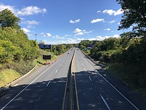
Two main highways pass through or near Wilson: U.S. Route 22 and Pennsylvania Route 248. US 22, also known as the Lehigh Valley Thruway, runs along the western and northern edges of the borough. PA 248, which is Northampton Street, goes through the middle of Wilson.
Education in Wilson
The Wilson Area School District serves the students in Wilson Borough. Students in grades nine through 12 attend Wilson Area High School, which is located right in the borough.
See also
 In Spanish: Wilson (Pensilvania) para niños
 | George Robert Carruthers |
 | Patricia Bath |
 | Jan Ernst Matzeliger |
 | Alexander Miles |


