Wilson Peak facts for kids
Quick facts for kids Wilson Peak |
|
|---|---|

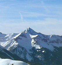
Wilson peak photographed from the Telluride Ski Resort
|
|
| Highest point | |
| Elevation | 14,023 ft (4,274 m) |
| Prominence | 857 ft (261 m) |
| Isolation | 1.51 mi (2.43 km) |
| Listing |
|
| Geography | |
| Location | High point of San Miguel County, Colorado, United States |
| Parent range | San Miguel Mountains |
| Topo map | USGS 7.5' topographic map Mount Wilson, Colorado |
| Climbing | |
| Easiest route | Southwest ridge from Silver Pick or Navajo Basins |
Wilson Peak is a tall mountain peak in the state of Colorado, United States. It stands at about 14,023 feet (4,274 meters) high. This makes it one of Colorado's "fourteeners," which are mountains over 14,000 feet tall.
Wilson Peak is found in the Lizard Head Wilderness, which is a protected natural area. It's also part of the Uncompahgre National Forest, a large forest managed by the U.S. government. The mountain is located in the northwestern part of the San Juan Mountains. It is the highest point in San Miguel County.
The mountain was named after A.D. Wilson. He was a main mapmaker for the Hayden Survey, a group that explored and mapped the American West. Another nearby mountain, Mount Wilson, is also named in his honor.
Where is Wilson Peak Located?
Wilson Peak is in the western part of the San Juan Mountains. This area is sometimes called the San Miguel Mountains or the Wilson Massif. There are two other very tall mountains, also "fourteeners," close to Wilson Peak. These are Mount Wilson, which is about 14,256 feet (4,345 meters) tall, and El Diente Peak, which is about 14,159 feet (4,316 meters) tall. They are all within 2 miles (3 kilometers) of each other.
Gladstone Peak, which is about 13,913 feet (4,241 meters) high, is also nearby. It sits on the ridge that connects Wilson Peak and Mount Wilson.

Climbing Wilson Peak
Many people climb Wilson Peak every year. Most climbers visit during the summer months when the weather is warmer. However, some people also climb it in winter. Winter climbs are sometimes used as a starting point for backcountry skiing, where skiers go off-trail down the mountain.
Summer climbs of Wilson Peak are considered "Class 3" climbs. This means you need to scramble over rocks, using your hands for balance. You usually don't need ropes for these climbs.
Popular Climbing Route
The easiest way to climb Wilson Peak starts at the Rock of Ages Trailhead. This spot is about 10,350 feet (3,155 meters) high and is located about 18 miles (29 kilometers) west of Telluride, Colorado.
- From the trailhead, you follow Forest Trail 429 southeast. This trail goes through a place called Silver Pick Basin.
- You then reach the Rock of Ages Saddle, which is a low point between Silver Pick and Navajo Basins. This saddle is about 13,100 feet (3,993 meters) high.
- Next, you follow Forest Trail 408 east to about 13,200 feet (4,023 meters). This takes you to the saddle between Gladstone Peak and Wilson Peak.
- Finally, you climb the ridge northeast to reach the very top of Wilson Peak.
The entire trip, going up and back down, is about 10 miles (16 kilometers) long.
 | Jackie Robinson |
 | Jack Johnson |
 | Althea Gibson |
 | Arthur Ashe |
 | Muhammad Ali |


