Winfield, Missouri facts for kids
Quick facts for kids
Winfield, Missouri
|
|
|---|---|

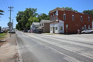
Winfield in June 2018
|
|

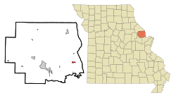
Location of Winfield, Missouri
|
|
| Country | United States |
| State | Missouri |
| County | Lincoln |
| Area | |
| • Total | 0.85 sq mi (2.20 km2) |
| • Land | 0.85 sq mi (2.20 km2) |
| • Water | 0.00 sq mi (0.00 km2) |
| Elevation | 548 ft (167 m) |
| Population
(2020)
|
|
| • Total | 1,518 |
| • Density | 1,787.99/sq mi (689.98/km2) |
| Time zone | UTC-6 (Central (CST)) |
| • Summer (DST) | UTC-5 (CDT) |
| ZIP code |
63389
|
| Area code(s) | 636 |
| FIPS code | 29-80422 |
| GNIS feature ID | 2397345 |
Winfield is a small city located in Lincoln County, Missouri, in the United States. In 2020, about 1,518 people lived there. It is known for its quiet community and interesting past events.
Contents
History of Winfield
Winfield was first started in 1879. It was named after Winfield Scott Killam, who owned the land where the city was built. A post office opened in Winfield in 1880, which helped people send and receive mail.
The 2008 Flood in Winfield
In June 2008, Winfield faced a big flood. The Mississippi River overflowed, causing a 150-foot wide break in a main levee (a wall built to stop water). This break allowed floodwaters to cover many homes and farms. People living east of Winfield had to leave their homes for safety. Some found shelter at the local high school.
Unusual Election in 2009
Winfield made headlines in April 2009 because of a very unusual election. The city's popular mayor, Harry Stonebraker, was re-elected for his fourth term. However, he had sadly passed away from a heart attack several weeks before the election day.
This happened because the ballot papers (the papers used for voting) had already been printed. Also, many people had already voted early using absentee voting (voting by mail before election day). Mayor Stonebraker won by a lot, getting 90% of the votes. After this, Winfield chose a temporary mayor until a special election could be held in April 2010.
Geography of Winfield
Winfield is a small city. According to the United States Census Bureau, the city covers a total area of about 0.64 square miles (1.66 square kilometers). All of this area is land, meaning there are no large lakes or rivers within the city limits.
Population and People
| Historical population | |||
|---|---|---|---|
| Census | Pop. | %± | |
| 1880 | 30 | — | |
| 1900 | 440 | — | |
| 1910 | 422 | −4.1% | |
| 1920 | 418 | −0.9% | |
| 1930 | 386 | −7.7% | |
| 1940 | 484 | 25.4% | |
| 1950 | 474 | −2.1% | |
| 1960 | 564 | 19.0% | |
| 1970 | 620 | 9.9% | |
| 1980 | 592 | −4.5% | |
| 1990 | 672 | 13.5% | |
| 2000 | 723 | 7.6% | |
| 2010 | 1,404 | 94.2% | |
| 2020 | 1,518 | 8.1% | |
| U.S. Decennial Census | |||
Winfield's Population in 2010
During the 2010 census, there were 1,404 people living in Winfield. These people lived in 525 households, with 360 of them being families. The city had about 2,194 people per square mile.
Most of the people living in Winfield were White (97.0%). A small number of residents were from other racial backgrounds. About 1.3% of the population identified as Hispanic or Latino.
The average age of people in Winfield was 31 years old. About 28.4% of the residents were under 18 years old. Around 8.5% of the population was 65 years old or older. The number of males and females in the city was almost equal.
Education in Winfield
Winfield has its own school district, called the Winfield R-IV School District. This district has four different schools that serve students from kindergarten through high school:
- Primary School (Kindergarten to 2nd grade)
- Intermediate School (3rd to 5th grade)
- Middle School (6th to 8th grade)
- High School (9th to 12th grade)
See also
 In Spanish: Winfield (Misuri) para niños
 | Sharif Bey |
 | Hale Woodruff |
 | Richmond Barthé |
 | Purvis Young |

