Winterville, Georgia facts for kids
Quick facts for kids
Winterville, Georgia
|
||
|---|---|---|
|
||
| Nickname(s):
The Marigold Capital of Georgia, the Friendship City
|
||

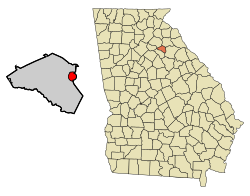
Location in Clarke County and the state of Georgia
|
||
| Country | United States | |
| State | Georgia | |
| County | Clarke | |
| Incorporated | 1904 | |
| Area | ||
| • Total | 2.65 sq mi (6.85 km2) | |
| • Land | 2.62 sq mi (6.78 km2) | |
| • Water | 0.03 sq mi (0.07 km2) | |
| Elevation | 797 ft (243 m) | |
| Population
(2020)
|
||
| • Total | 1,201 | |
| • Density | 458.40/sq mi (177.01/km2) | |
| Time zone | UTC-5 (Eastern (EST)) | |
| • Summer (DST) | UTC-4 (EDT) | |
| ZIP code |
30683
|
|
| Area code(s) | 706 | |
| FIPS code | 13-83728 | |
| GNIS feature ID | 2405776 | |
Winterville is a small city in Clarke County, Georgia, in the United States. It's sometimes called "The Marigold Capital of Georgia" or "The Friendship City." In 2020, about 1,200 people lived there.
Contents
History of Winterville
Winterville got its name from John Winter, who worked for the railroad. The city officially became a city in 1904.
Since 1991, Winterville has been special. The nearby city of Athens joined with Clarke County to form one big government. This means Winterville is the only separate town left in Athens-Clarke County.
A cool project is happening near Winterville! An old railroad track is being turned into a paved walking trail called the "Firefly Trail." It's about 1.1 miles long so far. This trail will eventually connect to the "Georgia Hi–Lo Trail." When finished, this will be the longest paved trail and the longest arboretum (a place where many different trees are grown) in the United States!
Where is Winterville?
Winterville is located in Georgia, about 6 miles (10 kilometers) from the University of Georgia. The city covers an area of about 2.7 square miles (7 square kilometers). All of this area is land.
Winterville's Weather
Winterville has a humid subtropical climate. This means it has hot, humid summers and mild winters. The average temperature in January is about 42°F (5.6°C). In July, the average temperature is around 78°F (25.6°C). The city gets a good amount of rain throughout the year.
Who Lives in Winterville?
| Historical population | |||
|---|---|---|---|
| Census | Pop. | %± | |
| 1910 | 465 | — | |
| 1920 | 504 | 8.4% | |
| 1930 | 432 | −14.3% | |
| 1940 | 503 | 16.4% | |
| 1950 | 453 | −9.9% | |
| 1960 | 497 | 9.7% | |
| 1970 | 551 | 10.9% | |
| 1980 | 621 | 12.7% | |
| 1990 | 876 | 41.1% | |
| 2000 | 1,068 | 21.9% | |
| 2010 | 1,122 | 5.1% | |
| 2020 | 1,201 | 7.0% | |
| U.S. Decennial Census | |||
The population of Winterville has grown over the years. In 2020, there were 1,201 people living in the city. There were 449 households and 331 families.
Most people in Winterville are White (about 69%). About 18% are Black or African American. Other groups like Asian, Pacific Islander, and people of mixed races also live there. About 7% of the population is Hispanic or Latino.
Places to Visit in Winterville
Winterville has some interesting community buildings.
- Marigold Auditorium for Arts and Culture: This building was first built in 1953. It was used for many years but then became run down. Luckily, it has been fixed up and is now a great place for arts and culture events. The very first auditorium in Winterville burned down on its opening night a long time ago!
- Cultural Center: This center is located in what used to be the high school building, built in 1956. It's a place where people can learn and enjoy cultural activities.
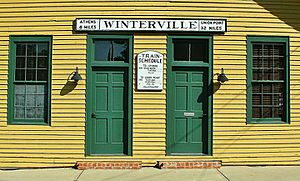
- Community Center: The Winterville Community Center is in an old train station. This train station was built in the late 1800s for the Georgia Railroad.
See also
 In Spanish: Winterville (Georgia) para niños
 | William Lucy |
 | Charles Hayes |
 | Cleveland Robinson |


