
Womboota facts for kids
Quick facts for kids WombootaNew South Wales |
|
|---|---|

School of Arts hall
|
|

Womboota
Location in New South Wales
|
|
| Population | 105 (2016 census) |
| Postcode(s) | 2731 |
| Elevation | 91 m (299 ft) |
| Location | |
| LGA(s) | Murray River Council |
| County | Cadell |
| State electorate(s) | Murray |
| Federal Division(s) | Farrer |
Womboota is a small community located in the central-southern part of the Riverina region in Australia. It's about 26 kilometers (16 miles) north of Moama and 28 kilometers (17 miles) southwest of Bunnaloo. In 2016, Womboota had a population of 105 people.
Contents
About Womboota
Womboota is part of the Deniliquin land district. It is also located within the area managed by the Murray River Council.
Past Transport Links
Womboota was once connected by the Balranald branch of the Deniliquin railway line. This railway line is no longer in use today.
History of the Post Office
The Womboota Post Office first opened its doors on 1 July 1899. It served the community for many years before closing down in 1979.
How the Name Changed
The name of the town was originally spelled "Wamboota". However, by the 1920s, the spelling "Womboota" became more common. Even in 1927, some newspapers still used the older spelling.
Images for kids
-
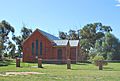
Womboota Uniting Church building
-
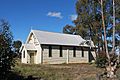
Womboota Roman Catholic Church building


