Wongarbon facts for kids
Quick facts for kids WongarbonNew South Wales |
|
|---|---|

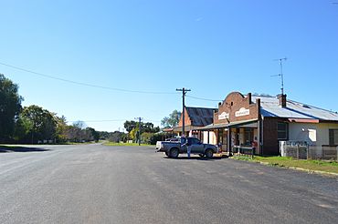
Main street
|
|
| Population | 766 (2016 census) |
| Postcode(s) | 2831 |
| Elevation | 390 m (1,280 ft) |
| Location | |
| LGA(s) | Dubbo Regional Council |
| County | Lincoln |
| Parish | Murrumbidgerie |
| State electorate(s) | Dubbo |
| Federal Division(s) | Parkes |
Wongarbon is a small village in New South Wales, Australia. It is about 18 kilometres east of Dubbo. You can find it on the Mitchell Highway, which connects Dubbo and Wellington. In 2016, Wongarbon had a population of 766 people.
Contents
History of Wongarbon
The land where Wongarbon is today traditionally belongs to the Wiradjuri people. They are the original inhabitants of this area.
Early Settlement and Land Use
After European settlers arrived, this area became part of Lincoln County. A large property called 'Murrumbidgerie' was here. By the 1850s, it was a busy place for raising sheep and cattle. An inn, or hotel, called the Murrumbidgerie Inn, opened by 1866.
How Wongarbon Village Began
The railway station in this area opened in February 1881. This was even before the village itself was officially created. In 1883, land was set aside for a new village. This land came from the 'Murrumbidgerie' property. The village was first called Murrumbidgerie. The local school opened in January 1887.
On October 20, 1888, the Village of Murrumbidgerie was officially announced. Land was also put aside for a common area and for water supply. The water supply came from a dam on Eulamoga Creek, called Wongarbon Tank. This dam provided water for the village for many years.
Changing the Village Name
In 1908, the village name changed from Murrumbidgerie to Wongarbon. The railway station and school also changed their names. The old name might have caused confusion with the Murrumbidgee River. The name 'Murrumbidgerie' is still used for an area closer to the Macquarie River.
The name 'Wongarbon' might be linked to the Wangaaypuwan people. However, Wongarbon is actually in Wiradjuri country. The old name, 'Murrumbidgerie', likely came from the Wiradjuri language. Another idea is that 'Wongarbon' is not an Aboriginal word. Some say it's 'no brag now' spelled backwards. This story involves a friendly rivalry between two local landowners.
Farming and Community Life
After the First World War, the rest of the 'Murrumbidgerie' land was divided. This was done to create farms for soldiers returning from the war. Growing wheat became very important in the area. The village's railway siding was used to send wheat by train.
Wongarbon once had a Uniting Church, which used to be a Methodist church. Now, it is a private building. There was also a Catholic church on Boberah Street, but it is now abandoned.
Wongarbon Nature Reserve
North of the village is the Wongarbon Nature Reserve. This area was first set aside in 1897 as common land for the village. It has become a special place for native plants and animals. It is a safe home for species that are threatened. In 2022, a local Aboriginal group, Pathways Together, began managing the reserve.
What Can You Find in Wongarbon?
Wongarbon has some useful places for its residents.
Local Facilities
The village has a primary school with three teachers. There is also a convenience store that includes the post office. You can also find a pub called 'The Ploughman's Rest'.
Transport and Connections
Wongarbon no longer has its own railway station. However, there are bus services to Dubbo. The closest railway stations are in Dubbo and Geurie. These stations have a daily train service. There is also a special railway siding for grain on the Main Western railway line. This siding has large sheds and a loader for trains to carry grain.
Other Local Features
About 3 kilometres from the village, there is a cemetery. Because Wongarbon is close to Dubbo, the village is growing. More people are choosing to live there.


