Woodgate, Indiana facts for kids
Quick facts for kids
Woodgate, Indiana
|
|
|---|---|

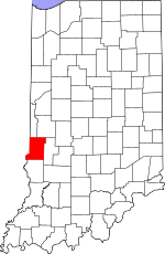
Vigo County's location in Indiana
|
|
| Country | United States |
| State | Indiana |
| County | Vigo |
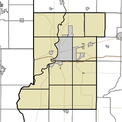
| Township | Honey Creek |
| Elevation | 561 ft (171 m) |
| Time zone | UTC-5 (Eastern (EST)) |
| • Summer (DST) | UTC-4 (EDT) |
| ZIP code |
47802
|
| Area code(s) | 812, 930 |
| GNIS feature ID | 446284 |
Woodgate is a small place in Indiana, a state in the United States. It is known as an "unincorporated community." This means it's a group of homes and businesses that doesn't have its own local government like a city or town. Instead, it's part of a larger area called Honey Creek Township in Vigo County.
Woodgate is also considered part of the Terre Haute metropolitan area. A metropolitan area includes a big city and all the smaller towns and communities around it that are connected.
Contents
What is an Unincorporated Community?
An unincorporated community like Woodgate doesn't have its own mayor or city council. It relies on the county or township for services. These services can include things like police, fire protection, and road maintenance.
Where is Woodgate Located?
Woodgate is found in the central part of Honey Creek Township. It's in Vigo County, which is in the state of Indiana.
Understanding Woodgate's Coordinates
To find Woodgate on a map, you can use its special location numbers. These are called geographic coordinates. Woodgate is located at 39°23′05″N 87°23′07″W / 39.38472°N 87.38528°W.
- The "N" means it's north of the Equator.
- The "W" means it's west of the Prime Meridian.
How High is Woodgate?
Woodgate sits at an elevation of 561 feet (which is about 171 meters) above sea level. This tells us how high up the land is compared to the ocean.
 | Kyle Baker |
 | Joseph Yoakum |
 | Laura Wheeler Waring |
 | Henry Ossawa Tanner |


