
Woodmere, Ohio facts for kids
Quick facts for kids
Woodmere, Ohio
|
|
|---|---|
|
Village
|
|

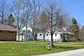
Houses on Brainard Road
|
|

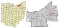
Location in Cuyahoga County and the state of Ohio
|
|
| Country | United States |
| State | Ohio |
| County | Cuyahoga |
| Government | |
| • Type | Mayor-council |
| Area | |
| • Total | 0.33 sq mi (0.85 km2) |
| • Land | 0.33 sq mi (0.85 km2) |
| • Water | 0.00 sq mi (0.00 km2) |
| Elevation | 1,210 ft (0 m) |
| Population
(2020)
|
|
| • Total | 641 |
| • Density | 1,960.24/sq mi (757.87/km2) |
| Time zone | UTC-4 (EST) |
| • Summer (DST) | UTC-4 (EDT) |
| Zip code |
44122
|
| Area code(s) | 216 |
| Website | http://www.woodmerevillage.com/ |
Woodmere is a small village located in Cuyahoga County, Ohio, in the United States. It's a suburb found to the east of Cleveland. In 2020, about 641 people lived in Woodmere. It is part of the larger Cleveland metropolitan area.
Contents
History of Woodmere Village
Woodmere is one of five communities that were once part of something called Orange Township. This township was famous for being the birthplace of President James A. Garfield.
While the other four communities became villages in the 1920s, Woodmere became its own village later, in 1944. Today, Woodmere is an important shopping and business area for all the places that used to be part of the original Orange Township. It's mainly centered along Chagrin Boulevard.
Where is Woodmere Located?
Woodmere is located at coordinates 41°27′33″N 81°28′52″W / 41.45917°N 81.48111°W. This means it's at 41.459253 degrees North latitude and -81.481010 degrees West longitude.
The United States Census Bureau says that Woodmere covers a total area of about 0.33 square miles (0.85 square kilometers). All of this area is land, meaning there are no large lakes or rivers within the village limits.
Population Changes in Woodmere
| Historical population | |||
|---|---|---|---|
| Census | Pop. | %± | |
| 1940 | 277 | — | |
| 1950 | 419 | 51.3% | |
| 1960 | 398 | −5.0% | |
| 1970 | 1,041 | 161.6% | |
| 1980 | 877 | −15.8% | |
| 1990 | 834 | −4.9% | |
| 2000 | 828 | −0.7% | |
| 2010 | 884 | 6.8% | |
| 2020 | 641 | −27.5% | |
| U.S. Decennial Census | |||
The population of Woodmere has changed over the years. In 1940, there were 277 people living there. The population grew quite a bit by 1970, reaching over 1,000 residents. Since then, the number of people living in Woodmere has gone up and down. In 2010, there were 884 people, but by 2020, the population was 641.
Who Lives in Woodmere?
In 2010, there were 884 people living in Woodmere. About 60.5% of the people were White, and 35.9% were African American. There were also smaller groups of Asian residents and people from other backgrounds. About 3.7% of the population identified as Hispanic or Latino.
The average age in the village was about 37.9 years old. Many different age groups live in Woodmere, including children, teenagers, adults, and older residents.
Schools Serving Woodmere
Students living in Woodmere attend schools that are part of the Orange City School System. This school system provides education for children and teens in the area.
Images for kids
-
Houses on Brainard Road
-
Location in Cuyahoga County and the state of Ohio
See Also
- In Spanish: Woodmere (Ohio) para niños
