Woolooga facts for kids
Quick facts for kids WooloogaQueensland |
|||||||||||||||
|---|---|---|---|---|---|---|---|---|---|---|---|---|---|---|---|

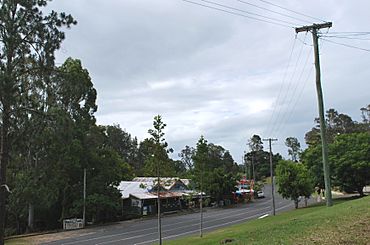
The main street of Woolooga, showing the general store, with the pub and community hall around the bend.
|
|||||||||||||||
| Population | 310 (2021 census) | ||||||||||||||
| • Density | 1.240/km2 (3.21/sq mi) | ||||||||||||||
| Established | 1910 | ||||||||||||||
| Postcode(s) | 4570 | ||||||||||||||
| Area | 250.1 km2 (96.6 sq mi) | ||||||||||||||
| Time zone | AEST (UTC+10:00) | ||||||||||||||
| Location | |||||||||||||||
| LGA(s) | Gympie Region | ||||||||||||||
| State electorate(s) |
|
||||||||||||||
| Federal Division(s) | Wide Bay | ||||||||||||||
|
|||||||||||||||
Woolooga is a small country town and local area in the Gympie Region of Queensland, Australia. It's a quiet place where about 310 people live. Woolooga is located about 221 kilometers (around 137 miles) north of Brisbane, which is the capital city of Queensland.
Contents
Exploring Woolooga's Location
The town of Woolooga is found in the southern part of its local area. A railway line used to run through the area, from Theebine to Nanango. This line is no longer used today. The town had its own train station called Woolooga railway station. There was also another station, Boowoogum railway station, in the eastern part of the area. Both of these stations are now closed.
A creek called Wide Bay Creek winds its way through the area. It flows from the south-west towards the east.
A Look Back at Woolooga's Past
Around 1848, a man named John Murray decided to become a "squatter." This meant he settled on land that wasn't officially his yet. He chose an area in northern New South Wales (which Queensland was part of back then). Murray settled on a large piece of land called the Walooga run, about 40 kilometers (25 miles) west of Gympie.
Even though Murray lived on Walooga for a few years, he didn't meet the rules to own the land. So, in 1850, the land was declared empty. Murray later joined the Australian native police, a special police force, and served for nearly 20 years.
In 1850, the government offered leases for the Walooga land. William Powell became the first official leaseholder in 1854. Later, in 1858, Robert Tooth took over the lease. He also leased other nearby areas. At this time, the land was mostly used for raising sheep for wool. By 1868, Walooga was described as an empty sheep station.
Woolooga was also a place where conflicts happened between settlers and Aboriginal people in the 1850s and 1860s.
In 1875 and 1876, brothers Robert Stuart Lord and Alfred Percy Lord won land in special lotteries called "selection ballots." This allowed them to buy land from the government.
The Woolooga railway station was named in 1886 by the Queensland Railways Department. This name then became used for the town and the whole area. It's believed that "Woolooga" comes from an Aboriginal word from the Kabi language. Wului means smoke and tha means ground or place.
Woolooga State School, the local primary school, first opened its doors on January 20, 1913.
The Woolooga Memorial Park is a special place in Thomas Street. It remembers people from the area who served in wars.
Woolooga was affected by big floods in 2010 and 2011. A wall of water, about 2 meters (6.5 feet) high, rushed through the town. It flooded the community hall and the local pub. The general store was also badly damaged by the floodwaters.
Woolooga's Population Over Time
The number of people living in Woolooga has changed over the years:
- In 2006, about 319 people lived in Woolooga and the surrounding rural area.
- By 2011, the population was around 274 people.
- In 2016, it was about 247 people.
- The most recent count in 2021 showed the population had grown to 310 people.
Special Places in Woolooga
Woolooga has some places that are listed for their historical importance:
- The Woolooga Rail Bridge is part of the old railway line that ran from Theebine to Kilkivan. It's an important historical structure.
Education in Woolooga
Woolooga State School is a government primary school for students from Prep to Year 6. It's located on Edwards Road. In 2018, the school had 14 students.
There isn't a secondary school right in Woolooga. Students who want to continue their education after primary school usually go to Kilkivan State School in nearby Kilkivan, which goes up to Year 10. For older students, James Nash State High School in Gympie is another option.
Community Spots and Services
Woolooga Memorial Park is a central gathering place in Thomas Street, at the corner of Booker Street. It's a park that honors Australians who have served in wars. Their names are listed on a special brass Honour Roll.


