Woolwine, Virginia facts for kids
Quick facts for kids
Woolwine
|
|
|---|---|
| Country | United States |
| State | Virginia |
| County | Patrick |
| Area | |
| • Total | 170 sq mi (430 km2) |
| Time zone | UTC−5 (Eastern (EST)) |
| • Summer (DST) | UTC−4 (EDT) |
| ZIP codes |
24185
|
| GNIS feature ID | 1500355 |
Woolwine is a small place in northern Patrick County, Virginia, United States. It's called an unincorporated community, which means it doesn't have its own local government like a city or town.
You'll find Woolwine where State Route 40 ends and meets State Route 8. This community is also part of the Rocky Knob American Viticultural Area, which is a special region known for growing grapes to make wine.
Famous Bridges in Woolwine
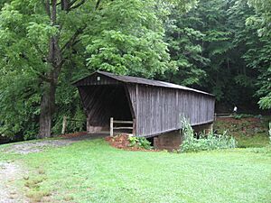
Woolwine is famous for its covered bridges, which are bridges with roofs and sides. These bridges help protect the wooden structure from weather.
- The Jack's Creek Covered Bridge was built in 1914.
- The Clifford Wood Covered Bridge was built more recently in 1977 and is privately owned.
Both of these bridges cross the Smith River. Sadly, the Bob White Covered Bridge, built in 1921, was destroyed by a big flood on September 29, 2015. It also crossed the Smith River.
Location and Nature
Woolwine is located at the bottom of the beautiful Blue Ridge Mountains. The community is about 430 meters (1,411 feet) above sea level. The famous Blue Ridge Parkway, a scenic road, is about 10 kilometers (6 miles) northwest of Woolwine if you follow State Route 8.
Local Heroes
A well-known baseball player named Herb Hash was born right here in Woolwine.
Weather in Woolwine
The weather in Woolwine has hot and humid summers. The winters are usually mild to cool. According to a system called Köppen Climate Classification, Woolwine has a humid subtropical climate. This means it gets plenty of rain all year, and the temperatures are generally warm.
 | Anna J. Cooper |
 | Mary McLeod Bethune |
 | Lillie Mae Bradford |


