
Yalgoo, Western Australia facts for kids
Quick facts for kids YalgooWestern Australia |
|||||||||
|---|---|---|---|---|---|---|---|---|---|

View of Yalgoo from Yalgoo lookout, September 2021
|
|||||||||

Yalgoo
Location in Western Australia
|
|||||||||
| Established | 1896 | ||||||||
| Postcode(s) | 6635 | ||||||||
| Elevation | 318 m (1,043 ft) | ||||||||
| Area | [convert: needs a number] | ||||||||
| Location | |||||||||
| LGA(s) | Shire of Yalgoo | ||||||||
| State electorate(s) | North West | ||||||||
| Federal Division(s) | Durack | ||||||||
|
|||||||||
Yalgoo is a small town located in the Mid West region of Western Australia. It's about 499 kilometers (310 miles) north-east of Perth, the capital city. Yalgoo is also about 118 kilometers (73 miles) east of Mullewa. This town is part of the Shire of Yalgoo local government area.
Before Yalgoo became a town, the land was used by early European settlers for grazing sheep. Families like the Morrisseys and Broads brought their sheep here. They used the rich pastures during the wet season. Then, they moved the sheep back to coastal areas for shearing before summer. Over time, these graziers saw how valuable the Yalgoo land was. They began to set up the first sheep stations, which are large sheep farms.
Contents
Discovering Gold in Yalgoo
Gold was found in the Yalgoo area in the early 1890s. By 1895, about 120 men were working at the gold sites. Buildings started to go up as more people arrived. The person in charge of the goldfield asked for a town to be planned and officially recognized. After a survey, the town of Yalgu was officially named in January 1896.
Yalgoo was once an important stop on the Northern Railway. The railway station opened in 1896. However, Yalgoo's importance decreased after World War II. This was because a new all-weather road was built. This road connected Wubin and Paynes Find, crossing Lake Moore. In early 1898, the town had a population of 650 people. This included 500 men and 150 women.
The St Hyacinth Convent School
In 1921-1922, a special priest named Monsignor John Hawes designed and built a school. He was the local priest for Yalgoo and Mullewa. This school was for the Dominican convent and included a chapel called St Hyacinth. Children in Yalgoo went to this school. However, it closed in 1950 because there were not enough students. The wooden school building was taken apart and moved. The chapel was left empty for a while. But it was fixed up and reopened in 1981.
In July 1931, work began on a state battery. This machine was used to crush rocks to get gold out. It was finished in October of the same year.
What Does the Name Yalgoo Mean?
The name Yalgoo comes from an Aboriginal word. It was first written down by a surveyor named John Forrest in 1876. He used it for Yalgoo Peak. The name is believed to mean "blood" or "place of blood." It comes from the word "Yalguru." Another idea is that it comes from the Yalguru bush. This bush grows a lot in the area and has a red sap that looks like blood.
At first, the spelling "Yalgu" was used. This was because of rules for spelling Aboriginal names. The letter "u" was thought to sound like "oo." But within a month, the Department of Lands and Surveys decided to use the original spelling, Yalgoo. This spelling has been used ever since. There was some confusion about the spelling change. So, an official change from Yalgu to Yalgoo was made in 1938.
Yalgoo's Climate
Yalgoo has a hot desert climate. This means it has very hot summers and mild winters.
| Climate data for Yalgoo | |||||||||||||
|---|---|---|---|---|---|---|---|---|---|---|---|---|---|
| Month | Jan | Feb | Mar | Apr | May | Jun | Jul | Aug | Sep | Oct | Nov | Dec | Year |
| Record high °C (°F) | 46.1 (115.0) |
46.1 (115.0) |
44.5 (112.1) |
40.6 (105.1) |
34.4 (93.9) |
29.1 (84.4) |
28.9 (84.0) |
33.9 (93.0) |
36.6 (97.9) |
40.0 (104.0) |
42.4 (108.3) |
45.0 (113.0) |
46.1 (115.0) |
| Mean daily maximum °C (°F) | 37.2 (99.0) |
36.3 (97.3) |
33.5 (92.3) |
28.5 (83.3) |
23.0 (73.4) |
19.2 (66.6) |
18.2 (64.8) |
20.0 (68.0) |
24.0 (75.2) |
27.5 (81.5) |
32.1 (89.8) |
35.5 (95.9) |
27.9 (82.2) |
| Mean daily minimum °C (°F) | 20.7 (69.3) |
20.7 (69.3) |
18.6 (65.5) |
14.5 (58.1) |
10.1 (50.2) |
7.7 (45.9) |
6.2 (43.2) |
6.8 (44.2) |
8.7 (47.7) |
11.4 (52.5) |
15.2 (59.4) |
18.4 (65.1) |
13.2 (55.8) |
| Record low °C (°F) | 9.4 (48.9) |
10.0 (50.0) |
6.8 (44.2) |
3.9 (39.0) |
−0.3 (31.5) |
−1.1 (30.0) |
−2.5 (27.5) |
−0.6 (30.9) |
−0.6 (30.9) |
0.4 (32.7) |
4.4 (39.9) |
7.0 (44.6) |
−2.5 (27.5) |
| Average precipitation mm (inches) | 15.8 (0.62) |
25.1 (0.99) |
25.2 (0.99) |
20.8 (0.82) |
31.3 (1.23) |
41.5 (1.63) |
35.2 (1.39) |
25.7 (1.01) |
11.7 (0.46) |
8.2 (0.32) |
8.0 (0.31) |
11.1 (0.44) |
260.8 (10.27) |
| Average precipitation days | 2.5 | 2.9 | 3.1 | 3.1 | 5.2 | 8.0 | 7.8 | 6.3 | 3.6 | 2.5 | 1.8 | 1.8 | 48.6 |
Yalgoo's Name Beyond Earth
The name Yalgoo is also used for a crater on the planet Mars. This crater is not named after the town specifically. It just happens to share the same name.
Images for kids
-
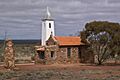
Convent of St Hyacinth, Yalgoo, 1922, side view
-
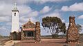
Convent of St Hyacinth, Yalgoo, 1922, front view


